Lenchwe Le Tau geodata
Lenchwe Le Tau (Kweneng) is a populated place; located in Botswana in Africa/Gaborone (GMT+2) time zone. With population of 4,992 people, there are 29 cities with bigger population in this country. Compared to other cities in Botswana, 67.6% of cities are located further ↑North; 50.5% of cities are located further →East and 76.2% of cities have lower elevation than Lenchwe Le Tau. Note1


Lenchwe Le Tau GPS coordinates[2]
24° 22' 59.988" South, 25° 51' 0" East
| Map corner | latitude | longitude |
|---|---|---|
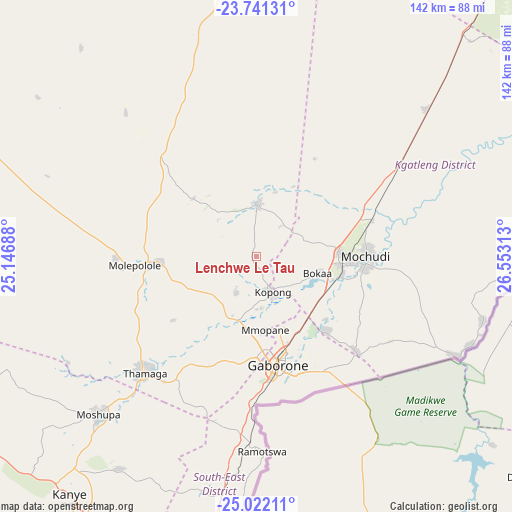
| Upper-left | -23.74131°, | 25.14688° |
| Center: | -24.38333°, | 25.85° |
| Lower-right: | -25.02211°, | 26.55313° |
| Map W x H: | 142.4×142.4 km | = 88.5×88.5mi |
| max Lat: | -17.80165° ⇑67.6% North |
| Lenchwe Le Tau: | -24.38333° |
| min Lat: | ⇓32.4% South -26.9° |
| min Long | Lenchwe Le Tau | max Long |
| 20.06667° | 25.85° | 28.74946° |
| W 49.5%⇐ | ⇒50.5% E |
Elevation
Elevation of Lenchwe Le Tau is 1107 m = 3632 ft, and this is 92 m = 302 ft above average elevation for this country.
| Max E: |
1406 m = 4613 ft | 23.8% |
| Lenchwe Le Tau | 1107 m 3632 ft | |
| Avg. | 1015 m = 3330 ft | |
Min E: |
676 m = 2218 ft | 76.2% |
See also: Botswana elevation on elevation.city.
Geographical zone
Lenchwe Le Tau is located in South temperate zone (between Tropic of Capricorn and the Antarctic Circle). Distance of this Southern Tropic circle is 105.3 km =65.4 mi to North.| Distance of | km | miles | from Lenchwe Le Tau |
|---|---|---|---|
| Equator | 2711.2 | 1684.7 | to North |
| Tropic Capricorn | 105.3 | 65.4 | to North |
| Antarctic Circle | 4690 | 2914.2 | to South |
| South Pole | 7295.9 | 4533.5 | to South |


Nearby cities:
15 places around Lenchwe Le Tau: (largest is in red/bold)
• Bokaa
18.4 km =11.4 mi,  113°
113°
• Dumadumana
22.8 km =14.2 mi,  173°
173°
• Gabane
32.2 km =20 mi,  192°
192°
• Gaborone
30.7 km =19.1 mi, 168°
• Galekgatshwane
15.7 km =9.8 mi,  195°
195°
• Gaphatshwe
21.2 km =13.2 mi,  184°
184°
• Kgaphamadi
18.9 km =11.7 mi,  155°
155°
• Kopong
11.6 km =7.2 mi, 163°
• Metsemotlhaba
19.3 km =12 mi, 194°
• Mmopone
20.6 km =12.8 mi, 173°
• Mochudi
30.6 km =19 mi,  96°
96°
• Mogoditshane
27.1 km =16.8 mi, 176°
• Mononyane
19.3 km =12 mi, 204°
• Nkoyaphiri
27.7 km =17.2 mi, 183°
• Pilane
29.6 km =18.4 mi, 104°
Sources, notices
• [Note1] Compared only with cities in Botswana existing in our database
• [Src1] Map data: © OpenStreetMap contributors (CC-BY-SA)
• [Src2] Other city data from geonames.org with taken over terms of usage.
• [Src3] Geographical zone / Annual Mean Temperature by Robert A. Rohde @ Wikipedia
