Gaborone geodata
Gaborone is a capital of a political entity; located in Botswana in Africa/Gaborone (GMT+2) time zone. With population of 208,411 people, there are 0 cities with bigger population in this country. Compared to other cities in Botswana, 84.8% of cities are located further ↑North; 55.2% of cities are located further ←West and 56.2% of cities have lower elevation than Gaborone. Note1


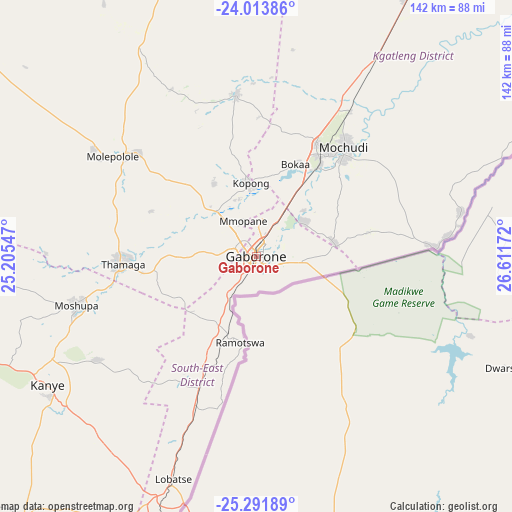
Gaborone GPS coordinates[2]
24° 39' 16.236" South, 25° 54' 30.924" East
| Map corner | latitude | longitude |
|---|---|---|
| Upper-left | -24.01386°, | 25.20547° |
| Center: | -24.65451°, | 25.90859° |
| Lower-right: | -25.29189°, | 26.61172° |
| Map W x H: | 142.1×142.1 km | = 88.3×88.3mi |
| max Lat: | -17.80165° ⇑84.8% North |
| Gaborone: | -24.65451° |
| min Lat: | ⇓15.2% South -26.9° |
| min Long | Gaborone | max Long |
| 20.06667° | 25.90859° | 28.74946° |
| W 55.2%⇐ | ⇒44.8% E |
Elevation
Elevation of Gaborone is 1011 m = 3317 ft, and this is 4 m = 13 ft below average elevation for this country.
| Max E: |
1406 m = 4613 ft | 43.8% |
| Avg. | 1015 m = 3330 ft | |
| Gaborone | 1011 m = 3317 ft | |
Min E: |
676 m = 2218 ft | 56.2% |
See also: Gaborone elevation on elevation.city.
Geographical zone
Gaborone is located in South temperate zone (between Tropic of Capricorn and the Antarctic Circle). Distance of this Southern Tropic circle is 135.4 km =84.1 mi to North.| Distance of | km | miles | from Gaborone |
|---|---|---|---|
| Equator | 2741.3 | 1703.4 | to North |
| Tropic Capricorn | 135.4 | 84.1 | to North |
| Antarctic Circle | 4659.8 | 2895.5 | to South |
| South Pole | 7265.7 | 4514.7 | to South |


Nearby cities:
15 places around Gaborone: (largest is in red/bold)
• Bokaa
25.2 km =15.7 mi,  25°
25°
• Dumadumana
8.2 km =5.1 mi,  335°
335°
• Gabane
12.8 km =8 mi,  263°
263°
• Galekgatshwane
18.2 km =11.3 mi,  325°
325°
• Gaphatshwe
11.7 km =7.3 mi,  319°
319°
• Kgaphamadi
13.1 km =8.1 mi,  8°
8°
• Kopong
19.2 km =11.9 mi,  352°
352°
• Lenchwe Le Tau
30.7 km =19.1 mi, 348°
• Metsemotlhaba
15.7 km =9.8 mi, 317°
• Mmokolodi
11.8 km =7.3 mi,  246°
246°
• Mmopone
10.3 km =6.4 mi, 340°
• Mogoditshane
5.3 km =3.3 mi,  305°
305°
• Mononyane
18.7 km =11.6 mi, 312°
• Nkoyaphiri
8.2 km =5.1 mi,  287°
287°
• Ramotswa
24.5 km =15.2 mi,  189°
189°
Sources, notices
• [Note1] Compared only with cities in Botswana existing in our database
• [Src1] Map data: © OpenStreetMap contributors (CC-BY-SA)
• [Src2] Other city data from geonames.org with taken over terms of usage.
• [Src3] Geographical zone / Annual Mean Temperature by Robert A. Rohde @ Wikipedia
