Nyehorelaye geodata
Nyehorelaye (Minsk) is a populated place; located in Belarus in Europe/Minsk (GMT+3) time zone. With population of 1,000 people, there are 247 cities with bigger population in this country. Compared to other cities in Belarus, 56.9% of cities are located further ↑North; 66.4% of cities are located further →East and 69.4% of cities have lower elevation than Nyehorelaye. Note1


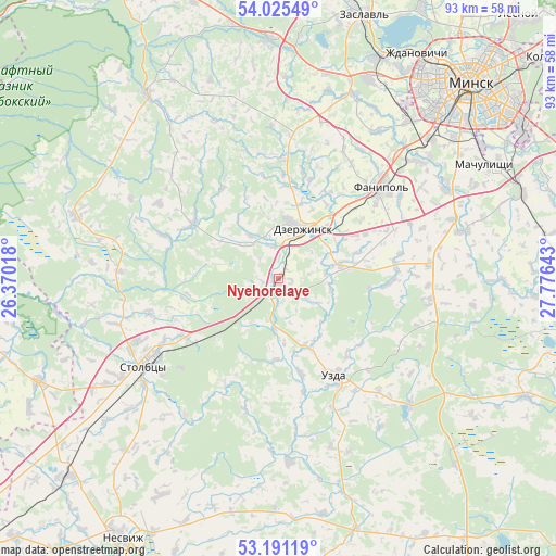
Nyehorelaye GPS coordinates[2]
53° 36' 37.44" North, 27° 4' 23.88" East
| Map corner | latitude | longitude |
|---|---|---|
| Upper-left | 54.02549°, | 26.37018° |
| Center: | 53.6104°, | 27.0733° |
| Lower-right: | 53.19119°, | 27.77643° |
| Map W x H: | 92.8×92.8 km | = 57.7×57.7mi |
| max Lat: | 56.0147° ⇑56.9% North |
| Nyehorelaye: | 53.6104° |
| min Lat: | ⇓43.1% South 51.75° |
| min Long | Nyehorelaye | max Long |
| 23.37083° | 27.0733° | 32.578° |
| W 33.6%⇐ | ⇒66.4% E |
Elevation
Elevation of Nyehorelaye is 181 m = 594 ft, and this is 12.4 m = 41 ft above average elevation for this country.
| Max E: |
309 m = 1014 ft | 30.6% |
| Nyehorelaye | 181 m 594 ft | |
| Avg. | 168.6 m = 553 ft | |
Min E: |
108 m = 354 ft | 69.4% |
See also: Belarus elevation on elevation.city.
Geographical zone
Nyehorelaye is located in North temperate zone (between Tropic of Cancer and the Arctic Circle). Distance of this North polar circle is 1440.3 km =895 mi to North.| Distance of | km | miles | from Nyehorelaye |
|---|---|---|---|
| North Pole | 4046.1 | 2514.1 | to North |
| Arctic Circle | 1440.3 | 895 | to North |
| Tropic Cancer | 3355 | 2084.7 | to South |
| Equator | 5960.9 | 3703.9 | to South |


Nearby cities:
15 places around Nyehorelaye: (largest is in red/bold)
• Atolina
30.5 km =19 mi,  51°
51°
• Azyartso
33 km =20.5 mi,  39°
39°
• Charkasy
24.4 km =15.2 mi, 44°
• Dzyarzhynsk
9.1 km =5.7 mi,  27°
27°
• Enyerhyetykaw
2.9 km =1.8 mi,  206°
206°
• Fanipol
23.1 km =14.4 mi, 47°
• Khatsyezhyna
36.6 km =22.7 mi,  24°
24°
• Novosel’ye
35 km =21.7 mi,  13°
13°
• Novy Svyerzhan’
28.6 km =17.8 mi,  232°
232°
• Samakhvalavichy
31.8 km =19.8 mi,  63°
63°
• Schomyslitsa
34.2 km =21.3 mi, 46°
• Stan’kava
10.5 km =6.5 mi,  78°
78°
• Stowbtsy
26.3 km =16.3 mi,  236°
236°
• Uzda
18.9 km =11.7 mi,  150°
150°
• Yubilyeyny
37.5 km =23.3 mi, 51°
Sources, notices
• [Note1] Compared only with cities in Belarus existing in our database
• [Src1] Map data: © OpenStreetMap contributors (CC-BY-SA)
• [Src2] Other city data from geonames.org with taken over terms of usage.
• [Src3] Geographical zone / Annual Mean Temperature by Robert A. Rohde @ Wikipedia
