Mir geodata
Mir (Grodnenskaya) is a populated place; located in Belarus in Europe/Minsk (GMT+3) time zone. With population of 2,500 people, there are 172 cities with bigger population in this country. Compared to other cities in Belarus, 63.8% of cities are located further ↑North; 76% of cities are located further →East and 54.3% of cities have lower elevation than Mir. Note1


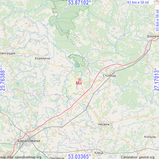
Mir GPS coordinates[2]
53° 27' 15.84" North, 26° 28' 1.2" East
| Map corner | latitude | longitude |
|---|---|---|
| Upper-left | 53.87102°, | 25.76388° |
| Center: | 53.4544°, | 26.467° |
| Lower-right: | 53.03365°, | 27.17013° |
| Map W x H: | 93.1×93.1 km | = 57.8×57.8mi |
| max Lat: | 56.0147° ⇑63.8% North |
| Mir: | 53.4544° |
| min Lat: | ⇓36.2% South 51.75° |
| min Long | Mir | max Long |
| 23.37083° | 26.467° | 32.578° |
| W 24%⇐ | ⇒76% E |
Elevation
Elevation of Mir is 170 m = 558 ft, and this is 1.4 m = 5 ft above average elevation for this country.
| Max E: |
309 m = 1014 ft | 45.7% |
| Mir | 170 m 558 ft | |
| Avg. | 168.6 m = 553 ft | |
Min E: |
108 m = 354 ft | 54.3% |
See also: Belarus elevation on elevation.city.
Geographical zone
Mir is located in North temperate zone (between Tropic of Cancer and the Arctic Circle). Distance of this North polar circle is 1457.6 km =905.7 mi to North.| Distance of | km | miles | from Mir |
|---|---|---|---|
| North Pole | 4063.5 | 2524.9 | to North |
| Arctic Circle | 1457.6 | 905.7 | to North |
| Tropic Cancer | 3337.7 | 2073.9 | to South |
| Equator | 5943.6 | 3693.2 | to South |


Nearby cities:
15 places around Mir: (largest is in red/bold)
• Enyerhyetykaw
41.5 km =25.8 mi,  69°
69°
• Haradzishcha
33.5 km =20.8 mi,  244°
244°
• Haradzyeya
16.5 km =10.3 mi,  163°
163°
• Karelichy
24.8 km =15.4 mi,  299°
299°
• Lyubcha
42.6 km =26.5 mi,  320°
320°
• Novy Svyerzhan’
17.4 km =10.8 mi,  90°
90°
• Nyasvizh
29.7 km =18.5 mi,  151°
151°
• Nyehorelaye
43.7 km =27.2 mi, 66°
• Rudawka
27.2 km =16.9 mi, 153°
• Shchorsy
27.3 km =17 mi, 317°
• Snow
26.4 km =16.4 mi,  189°
189°
• Stalovichy
39.1 km =24.3 mi,  226°
226°
• Stowbtsy
18.5 km =11.5 mi,  81°
81°
• Turets
13 km =8.1 mi,  308°
308°
• Vishnyavyets
19 km =11.8 mi,  128°
128°
Sources, notices
• [Note1] Compared only with cities in Belarus existing in our database
• [Src1] Map data: © OpenStreetMap contributors (CC-BY-SA)
• [Src2] Other city data from geonames.org with taken over terms of usage.
• [Src3] Geographical zone / Annual Mean Temperature by Robert A. Rohde @ Wikipedia
