Kamyanyuki geodata
Kamyanyuki (Brest) is a populated place; located in Belarus in Europe/Minsk (GMT+3) time zone. With population of 1,200 people, there are 236 cities with bigger population in this country. Compared to other cities in Belarus, 83.6% of cities are located further ↑North; 97.7% of cities are located further →East and 75.3% of cities have higher elevation than Kamyanyuki. Note1


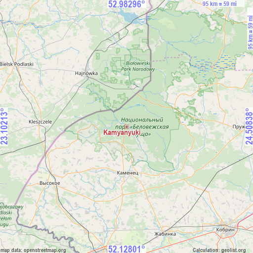
Kamyanyuki GPS coordinates[2]
52° 33' 27.252" North, 23° 48' 18.9" East
| Map corner | latitude | longitude |
|---|---|---|
| Upper-left | 52.98296°, | 23.10213° |
| Center: | 52.55757°, | 23.80525° |
| Lower-right: | 52.12801°, | 24.50838° |
| Map W x H: | 95.1×95.1 km | = 59.1×59.1mi |
| max Lat: | 56.0147° ⇑83.6% North |
| Kamyanyuki: | 52.55757° |
| min Lat: | ⇓16.4% South 51.75° |
| min Long | Kamyanyuki | max Long |
| 23.37083° | 23.80525° | 32.578° |
| W 2.3%⇐ | ⇒97.7% E |
Elevation
Elevation of Kamyanyuki is 146 m = 479 ft, and this is 22.6 m = 74 ft below average elevation for this country.
| Max E: |
309 m = 1014 ft | 75.3% |
| Avg. | 168.6 m = 553 ft | |
| Kamyanyuki | 146 m = 479 ft | |
Min E: |
108 m = 354 ft | 24.7% |
See also: Belarus elevation on elevation.city.
Geographical zone
Kamyanyuki is located in North temperate zone (between Tropic of Cancer and the Arctic Circle). Distance of this North polar circle is 1557.3 km =967.7 mi to North.| Distance of | km | miles | from Kamyanyuki |
|---|---|---|---|
| North Pole | 4163.2 | 2586.9 | to North |
| Arctic Circle | 1557.3 | 967.7 | to North |
| Tropic Cancer | 3237.9 | 2011.9 | to South |
| Equator | 5843.9 | 3631.2 | to South |


Nearby cities:
15 places around Kamyanyuki: (largest is in red/bold)
• Antopal’
77.3 km =48 mi,  120°
120°
• Brest
51.8 km =32.2 mi,  188°
188°
• Byaroza
79.4 km =49.3 mi,  92°
92°
• Charnawchytsy
37.8 km =23.5 mi, 186°
• Horad Kobryn
53.8 km =33.4 mi,  134°
134°
• Kamyanyets
17.5 km =10.9 mi,  178°
178°
• Kobryn
53.5 km =33.2 mi,  135°
135°
• Pruzhany
44.1 km =27.4 mi, 90°
• Skoki
46.2 km =28.7 mi, 194°
• Svislach
56.6 km =35.2 mi,  20°
20°
• Volkovysk
79.4 km =49.3 mi,  33°
33°
• Vyalikaya Byerastavitsa
72.4 km =45 mi,  11°
11°
• Vysokaye
36 km =22.4 mi,  234°
234°
• Zhabinka
42.3 km =26.3 mi,  160°
160°
• Znamenka
75.8 km =47.1 mi, 187°
Sources, notices
• [Note1] Compared only with cities in Belarus existing in our database
• [Src1] Map data: © OpenStreetMap contributors (CC-BY-SA)
• [Src2] Other city data from geonames.org with taken over terms of usage.
• [Src3] Geographical zone / Annual Mean Temperature by Robert A. Rohde @ Wikipedia
