Kamyanyets geodata
Kamyanyets (Brest) is a populated place; located in Belarus in Europe/Minsk (GMT+3) time zone. With population of 8,700 people, there are 96 cities with bigger population in this country. Compared to other cities in Belarus, 86.8% of cities are located further ↑North; 97.4% of cities are located further →East and 79.3% of cities have higher elevation than Kamyanyets. Note1


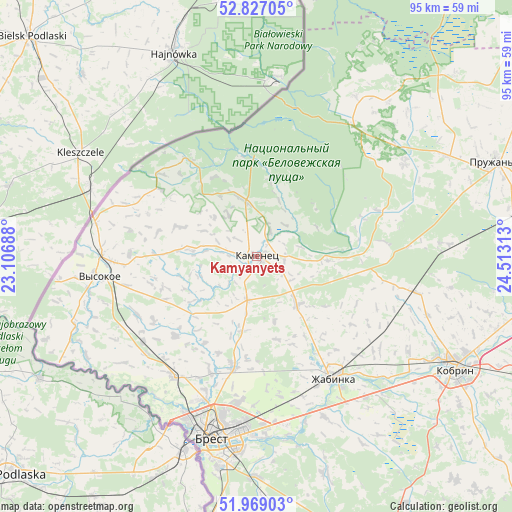
Kamyanyets GPS coordinates[2]
52° 24' 0.468" North, 23° 48' 36" East
| Map corner | latitude | longitude |
|---|---|---|
| Upper-left | 52.82705°, | 23.10688° |
| Center: | 52.40013°, | 23.81° |
| Lower-right: | 51.96903°, | 24.51313° |
| Map W x H: | 95.4×95.4 km | = 59.3×59.3mi |
| max Lat: | 56.0147° ⇑86.8% North |
| Kamyanyets: | 52.40013° |
| min Lat: | ⇓13.2% South 51.75° |
| min Long | Kamyanyets | max Long |
| 23.37083° | 23.81° | 32.578° |
| W 2.6%⇐ | ⇒97.4% E |
Elevation
Elevation of Kamyanyets is 141 m = 463 ft, and this is 27.6 m = 91 ft below average elevation for this country.
| Max E: |
309 m = 1014 ft | 79.3% |
| Avg. | 168.6 m = 553 ft | |
| Kamyanyets | 141 m = 463 ft | |
Min E: |
108 m = 354 ft | 20.7% |
See also: Belarus elevation on elevation.city.
Geographical zone
Kamyanyets is located in North temperate zone (between Tropic of Cancer and the Arctic Circle). Distance of this North polar circle is 1574.8 km =978.5 mi to North.| Distance of | km | miles | from Kamyanyets |
|---|---|---|---|
| North Pole | 4180.7 | 2597.8 | to North |
| Arctic Circle | 1574.8 | 978.5 | to North |
| Tropic Cancer | 3220.4 | 2001.1 | to South |
| Equator | 5826.3 | 3620.3 | to South |


Nearby cities:
15 places around Kamyanyets: (largest is in red/bold)
• Antopal’
69.9 km =43.4 mi,  108°
108°
• Brest
34.7 km =21.6 mi,  193°
193°
• Byaroza
80.5 km =50 mi,  79°
79°
• Charnawchytsy
20.6 km =12.8 mi, 193°
• Damachava
73.7 km =45.8 mi, 191°
• Horad Kobryn
43 km =26.7 mi,  118°
118°
• Kamyanyuki
17.5 km =10.9 mi,  358°
358°
• Kobryn
42.5 km =26.4 mi, 119°
• Malaryta
70.1 km =43.6 mi,  165°
165°
• Pruzhany
47.1 km =29.3 mi,  68°
68°
• Skoki
29.8 km =18.5 mi,  203°
203°
• Svislach
73.2 km =45.5 mi,  15°
15°
• Vysokaye
30 km =18.6 mi,  263°
263°
• Zhabinka
26.3 km =16.3 mi,  148°
148°
• Znamenka
58.6 km =36.4 mi, 190°
Sources, notices
• [Note1] Compared only with cities in Belarus existing in our database
• [Src1] Map data: © OpenStreetMap contributors (CC-BY-SA)
• [Src2] Other city data from geonames.org with taken over terms of usage.
• [Src3] Geographical zone / Annual Mean Temperature by Robert A. Rohde @ Wikipedia
