Abbotsford geodata
Abbotsford (British Columbia) is a populated place; located in Canada in America/Vancouver (GMT-7) time zone. With population of 151,683 people, there are 38 cities with bigger population in this country. Compared to other cities in Canada, 62.7% of cities are located further ↓South; 91.2% of cities are located further →East and 57.9% of cities have higher elevation than Abbotsford. Note1
Administrative division(s):
- Level 1: British Columbia
- Level 2: Fraser Valley Regional District
- Level 3: Abbotsford


Abbotsford GPS coordinates[2]
49° 3' 28.728" North, 122° 15' 9.252" West
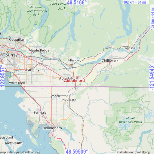
| Map corner | latitude | longitude |
|---|---|---|
| Upper-left | 49.5166°, | -122.9557° |
| Center: | 49.05798°, | -122.25257° |
| Lower-right: | 48.59509°, | -121.54945° |
| Map W x H: | 102.5×102.5 km | = 63.7×63.7mi |
| max Lat: | 73.03752° ⇑37.3% North |
| Abbotsford: | 49.05798° |
| min Lat: | ⇓62.7% South 42.05009° |
| min Long | Abbotsford | max Long |
| -139.43328° | -122.25257° | -52.70931° |
| W 8.8%⇐ | ⇒91.2% E |
Elevation
Elevation of Abbotsford is 114 m = 374 ft, and this is 140.4 m = 461 ft below average elevation for this country.
| Max E: |
1518 m = 4980 ft | 57.9% |
| Avg. | 254.4 m = 835 ft | |
| Abbotsford | 114 m = 374 ft | |
Min E: |
-2 m = -7 ft | 42.1% |
See also: Abbotsford elevation on elevation.city.
Geographical zone
Abbotsford is located in North temperate zone (between Tropic of Cancer and the Arctic Circle). Distance of this North polar circle is 1946.4 km =1209.4 mi to North.| Distance of | km | miles | from Abbotsford |
|---|---|---|---|
| North Pole | 4552.3 | 2828.7 | to North |
| Arctic Circle | 1946.4 | 1209.4 | to North |
| Tropic Cancer | 2848.8 | 1770.2 | to South |
| Equator | 5454.7 | 3389.4 | to South |


Nearby cities:
15 places around Abbotsford: (largest is in red/bold)
• Agassiz
40.2 km =25 mi,  61°
61°
• Aldergrove
15.9 km =9.9 mi,  270°
270°
• Aldergrove East
12.4 km =7.7 mi, 268°
• Baker Trails
23.2 km =14.4 mi,  82°
82°
• Bell Acres
28.1 km =17.5 mi,  85°
85°
• Chilliwack
24.9 km =15.5 mi, 61°
• Hatzic Island
11.9 km =7.4 mi,  5°
5°
• Langley
30 km =18.6 mi,  279°
279°
• Maple Ridge
31.1 km =19.3 mi,  305°
305°
• Mission
9.1 km =5.7 mi,  336°
336°
• Pitt Meadows
36.6 km =22.7 mi,  299°
299°
• Skowkale 10
24.2 km =15 mi,  68°
68°
• Surrey
42 km =26.1 mi, 277°
• Walnut Grove
30.6 km =19 mi,  292°
292°
• White Rock
40.4 km =25.1 mi,  263°
263°
Sources, notices
• [Note1] Compared only with cities in Canada existing in our database
• [Src1] Map data: © OpenStreetMap contributors (CC-BY-SA)
• [Src2] Other city data from geonames.org with taken over terms of usage.
• [Src3] Geographical zone / Annual Mean Temperature by Robert A. Rohde @ Wikipedia
