Aldergrove East geodata
Aldergrove East (British Columbia) is a populated place; located in Canada in America/Vancouver (GMT-7) time zone. With population of 3,491 people, there are 570 cities with bigger population in this country. Compared to other cities in Canada, 62.6% of cities are located further ↓South; 91.3% of cities are located further →East and 57.1% of cities have higher elevation than Aldergrove East. Note1
Administrative division(s):
- Level 1: British Columbia
- Level 2: Fraser Valley Regional District
- Level 3: Abbotsford


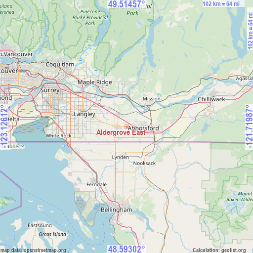
Aldergrove East GPS coordinates[2]
49° 3' 21.348" North, 122° 25' 22.764" West
| Map corner | latitude | longitude |
|---|---|---|
| Upper-left | 49.51457°, | -123.12612° |
| Center: | 49.05593°, | -122.42299° |
| Lower-right: | 48.59302°, | -121.71987° |
| Map W x H: | 102.5×102.5 km | = 63.7×63.7mi |
| max Lat: | 73.03752° ⇑37.4% North |
| Aldergrove East: | 49.05593° |
| min Lat: | ⇓62.6% South 42.05009° |
| min Long | Aldergrove East | max Long |
| -139.43328° | -122.42299° | -52.70931° |
| W 8.7%⇐ | ⇒91.3% E |
Elevation
Elevation of Aldergrove East is 121 m = 397 ft, and this is 133.4 m = 438 ft below average elevation for this country.
| Max E: |
1518 m = 4980 ft | 57.1% |
| Avg. | 254.4 m = 835 ft | |
| Aldergrove East | 121 m = 397 ft | |
Min E: |
-2 m = -7 ft | 42.9% |
See also: Canada elevation on elevation.city.
Geographical zone
Aldergrove East is located in North temperate zone (between Tropic of Cancer and the Arctic Circle). Distance of this North polar circle is 1946.7 km =1209.6 mi to North.| Distance of | km | miles | from Aldergrove East |
|---|---|---|---|
| North Pole | 4552.6 | 2828.9 | to North |
| Arctic Circle | 1946.7 | 1209.6 | to North |
| Tropic Cancer | 2848.6 | 1770 | to South |
| Equator | 5454.5 | 3389.3 | to South |


Nearby cities:
15 places around Aldergrove East: (largest is in red/bold)
• Abbotsford
12.4 km =7.7 mi,  88°
88°
• Aldergrove
3.5 km =2.2 mi,  273°
273°
• Baker Trails
35.5 km =22.1 mi,  84°
84°
• Chilliwack
36.4 km =22.6 mi,  70°
70°
• Coquitlam
36.4 km =22.6 mi,  314°
314°
• Hatzic Island
18.1 km =11.2 mi,  48°
48°
• Langley
17.9 km =11.1 mi,  286°
286°
• Maple Ridge
22.4 km =13.9 mi,  324°
324°
• Mission
12.3 km =7.6 mi, 45°
• Pitt Meadows
26.7 km =16.6 mi, 313°
• Port Coquitlam
34.4 km =21.4 mi, 312°
• Skowkale 10
36.1 km =22.4 mi, 75°
• Surrey
29.8 km =18.5 mi,  280°
280°
• Walnut Grove
19.9 km =12.4 mi, 307°
• White Rock
28 km =17.4 mi,  260°
260°
Sources, notices
• [Note1] Compared only with cities in Canada existing in our database
• [Src1] Map data: © OpenStreetMap contributors (CC-BY-SA)
• [Src2] Other city data from geonames.org with taken over terms of usage.
• [Src3] Geographical zone / Annual Mean Temperature by Robert A. Rohde @ Wikipedia
