Langley geodata
Langley (British Columbia) is a populated place; located in Canada in America/Vancouver (GMT-7) time zone. With population of 23,606 people, there are 169 cities with bigger population in this country. Compared to other cities in Canada, 63.5% of cities are located further ↓South; 91.8% of cities are located further →East and 91.2% of cities have higher elevation than Langley. Note1
Administrative division(s):
- Level 1: British Columbia
- Level 2: Metro Vancouver Regional District
- Level 3: Langley


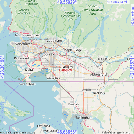
Langley GPS coordinates[2]
49° 6' 3.852" North, 122° 39' 31.788" West
| Map corner | latitude | longitude |
|---|---|---|
| Upper-left | 49.55929°, | -123.36196° |
| Center: | 49.10107°, | -122.65883° |
| Lower-right: | 48.63858°, | -121.95571° |
| Map W x H: | 102.4×102.4 km | = 63.6×63.6mi |
| max Lat: | 73.03752° ⇑36.5% North |
| Langley: | 49.10107° |
| min Lat: | ⇓63.5% South 42.05009° |
| min Long | Langley | max Long |
| -139.43328° | -122.65883° | -52.70931° |
| W 8.2%⇐ | ⇒91.8% E |
Elevation
Elevation of Langley is 13 m = 43 ft, and this is 241.4 m = 792 ft below average elevation for this country.
| Max E: |
1518 m = 4980 ft | 91.2% |
| Avg. | 254.4 m = 835 ft | |
| Langley | 13 m = 43 ft | |
Min E: |
-2 m = -7 ft | 8.8% |
See also: Canada elevation on elevation.city.
Geographical zone
Langley is located in North temperate zone (between Tropic of Cancer and the Arctic Circle). Distance of this North polar circle is 1941.6 km =1206.5 mi to North.| Distance of | km | miles | from Langley |
|---|---|---|---|
| North Pole | 4547.5 | 2825.7 | to North |
| Arctic Circle | 1941.6 | 1206.5 | to North |
| Tropic Cancer | 2853.6 | 1773.1 | to South |
| Equator | 5459.5 | 3392.4 | to South |


Nearby cities:
15 places around Langley: (largest is in red/bold)
• Aldergrove
14.5 km =9 mi,  109°
109°
• Aldergrove East
17.9 km =11.1 mi, 106°
• Anmore
27.8 km =17.3 mi,  329°
329°
• Burnaby
28.2 km =17.5 mi,  310°
310°
• Coquitlam
22.3 km =13.9 mi,  336°
336°
• Delta
18.7 km =11.6 mi,  284°
284°
• Maple Ridge
13.8 km =8.6 mi,  17°
17°
• Mission
26.2 km =16.3 mi,  82°
82°
• New Westminster
21.8 km =13.5 mi,  302°
302°
• Pitt Meadows
13.5 km =8.4 mi,  350°
350°
• Port Coquitlam
20.1 km =12.5 mi, 336°
• Port Moody
23.4 km =14.5 mi, 328°
• Surrey
12.1 km =7.5 mi,  272°
272°
• Walnut Grove
7.2 km =4.5 mi,  10°
10°
• White Rock
14.1 km =8.8 mi,  228°
228°
Sources, notices
• [Note1] Compared only with cities in Canada existing in our database
• [Src1] Map data: © OpenStreetMap contributors (CC-BY-SA)
• [Src2] Other city data from geonames.org with taken over terms of usage.
• [Src3] Geographical zone / Annual Mean Temperature by Robert A. Rohde @ Wikipedia
