Anmore geodata
Anmore (British Columbia) is a seat of a third-order administrative division; located in Canada in America/Vancouver (GMT-7) time zone. With population of 2,210 people, there are 717 cities with bigger population in this country. Compared to other cities in Canada, 68.2% of cities are located further ↓South; 92.7% of cities are located further →East and 52.1% of cities have lower elevation than Anmore. Note1
Administrative division(s):
- Level 1: British Columbia
- Level 2: Metro Vancouver Regional District
- Level 3: Anmore


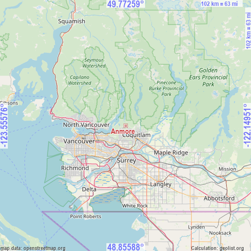
Anmore GPS coordinates[2]
49° 18' 58.932" North, 122° 51' 9.468" West
| Map corner | latitude | longitude |
|---|---|---|
| Upper-left | 49.77259°, | -123.55576° |
| Center: | 49.31637°, | -122.85263° |
| Lower-right: | 48.85588°, | -122.14951° |
| Map W x H: | 101.9×101.9 km | = 63.3×63.3mi |
| max Lat: | 73.03752° ⇑31.8% North |
| Anmore: | 49.31637° |
| min Lat: | ⇓68.2% South 42.05009° |
| min Long | Anmore | max Long |
| -139.43328° | -122.85263° | -52.70931° |
| W 7.3%⇐ | ⇒92.7% E |
Elevation
Elevation of Anmore is 183 m = 600 ft, and this is 71.4 m = 234 ft below average elevation for this country.
| Max E: |
1518 m = 4980 ft | 47.9% |
| Avg. | 254.4 m = 835 ft | |
| Anmore | 183 m = 600 ft | |
Min E: |
-2 m = -7 ft | 52.1% |
See also: Canada elevation on elevation.city.
Geographical zone
Anmore is located in North temperate zone (between Tropic of Cancer and the Arctic Circle). Distance of this North polar circle is 1917.7 km =1191.6 mi to North.| Distance of | km | miles | from Anmore |
|---|---|---|---|
| North Pole | 4523.6 | 2810.8 | to North |
| Arctic Circle | 1917.7 | 1191.6 | to North |
| Tropic Cancer | 2877.5 | 1788 | to South |
| Equator | 5483.5 | 3407.3 | to South |


Nearby cities:
15 places around Anmore: (largest is in red/bold)
• Arbutus Ridge
24.1 km =15 mi,  252°
252°
• Burnaby
9.1 km =5.7 mi,  232°
232°
• Coquitlam
6.2 km =3.9 mi,  124°
124°
• Delta
19.6 km =12.2 mi,  191°
191°
• Maple Ridge
21.1 km =13.1 mi, 120°
• New Westminster
12.9 km =8 mi,  199°
199°
• North Vancouver
15.7 km =9.8 mi,  269°
269°
• Pitt Meadows
15.9 km =9.9 mi,  131°
131°
• Port Coquitlam
8.2 km =5.1 mi, 132°
• Port Moody
4.4 km =2.7 mi,  152°
152°
• Surrey
23.4 km =14.5 mi,  175°
175°
• Vancouver
20.7 km =12.9 mi, 249°
• Walnut Grove
22.8 km =14.2 mi,  137°
137°
• West End
20.7 km =12.9 mi,  259°
259°
• West Vancouver
23.4 km =14.5 mi,  283°
283°
Sources, notices
• [Note1] Compared only with cities in Canada existing in our database
• [Src1] Map data: © OpenStreetMap contributors (CC-BY-SA)
• [Src2] Other city data from geonames.org with taken over terms of usage.
• [Src3] Geographical zone / Annual Mean Temperature by Robert A. Rohde @ Wikipedia
