Burnaby geodata
Burnaby (British Columbia) is a seat of a third-order administrative division; located in Canada in America/Vancouver (GMT-7) time zone. With population of 202,799 people, there are 27 cities with bigger population in this country. Compared to other cities in Canada, 67.3% of cities are located further ↓South; 92.9% of cities are located further →East and 62.9% of cities have higher elevation than Burnaby. Note1
Administrative division(s):
- Level 1: British Columbia
- Level 2: Metro Vancouver Regional District
- Level 3: Burnaby


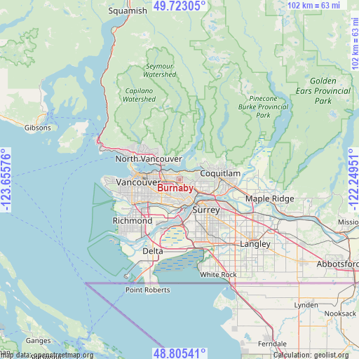
Burnaby GPS coordinates[2]
49° 15' 58.896" North, 122° 57' 9.468" West
| Map corner | latitude | longitude |
|---|---|---|
| Upper-left | 49.72305°, | -123.65576° |
| Center: | 49.26636°, | -122.95263° |
| Lower-right: | 48.80541°, | -122.24951° |
| Map W x H: | 102×102 km | = 63.4×63.4mi |
| max Lat: | 73.03752° ⇑32.7% North |
| Burnaby: | 49.26636° |
| min Lat: | ⇓67.3% South 42.05009° |
| min Long | Burnaby | max Long |
| -139.43328° | -122.95263° | -52.70931° |
| W 7.1%⇐ | ⇒92.9% E |
Elevation
Elevation of Burnaby is 87 m = 285 ft, and this is 167.4 m = 549 ft below average elevation for this country.
| Max E: |
1518 m = 4980 ft | 62.9% |
| Avg. | 254.4 m = 835 ft | |
| Burnaby | 87 m = 285 ft | |
Min E: |
-2 m = -7 ft | 37.1% |
See also: Burnaby elevation on elevation.city.
Geographical zone
Burnaby is located in North temperate zone (between Tropic of Cancer and the Arctic Circle). Distance of this North polar circle is 1923.3 km =1195.1 mi to North.| Distance of | km | miles | from Burnaby |
|---|---|---|---|
| North Pole | 4529.2 | 2814.3 | to North |
| Arctic Circle | 1923.3 | 1195.1 | to North |
| Tropic Cancer | 2872 | 1784.6 | to South |
| Equator | 5477.9 | 3403.8 | to South |


Nearby cities:
15 places around Burnaby: (largest is in red/bold)
• Anmore
9.1 km =5.7 mi,  52°
52°
• Arbutus Ridge
15.8 km =9.8 mi,  263°
263°
• Coquitlam
12.5 km =7.8 mi,  80°
80°
• Delta
14 km =8.7 mi,  166°
166°
• Ladner
21.8 km =13.5 mi,  205°
205°
• New Westminster
7.3 km =4.5 mi,  155°
155°
• North Vancouver
10.1 km =6.3 mi,  303°
303°
• Pitt Meadows
19.7 km =12.2 mi,  104°
104°
• Port Coquitlam
13.3 km =8.3 mi,  89°
89°
• Port Moody
9.4 km =5.8 mi, 79°
• Richmond
17.1 km =10.6 mi,  231°
231°
• Surrey
20.1 km =12.5 mi,  152°
152°
• Vancouver
12.2 km =7.6 mi, 261°
• West End
13.2 km =8.2 mi,  278°
278°
• West Vancouver
19.1 km =11.9 mi,  305°
305°
Sources, notices
• [Note1] Compared only with cities in Canada existing in our database
• [Src1] Map data: © OpenStreetMap contributors (CC-BY-SA)
• [Src2] Other city data from geonames.org with taken over terms of usage.
• [Src3] Geographical zone / Annual Mean Temperature by Robert A. Rohde @ Wikipedia
