Port Moody geodata
Port Moody (British Columbia) is a seat of a third-order administrative division; located in Canada in America/Vancouver (GMT-8) time zone. With population of 27,512 people, there are 152 cities with bigger population in this country. Compared to other cities in Canada, 67.6% of cities are located further ↓South; 92.5% of cities are located further →East and 81.3% of cities have higher elevation than Port Moody. Note1
Administrative division(s):
- Level 1: British Columbia
- Level 2: Metro Vancouver Regional District
- Level 3: Port Moody


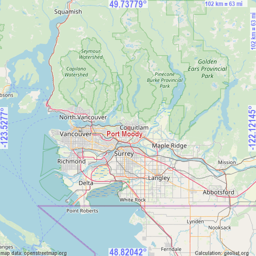
Port Moody GPS coordinates[2]
49° 16' 52.464" North, 122° 49' 28.452" West
| Map corner | latitude | longitude |
|---|---|---|
| Upper-left | 49.73779°, | -123.5277° |
| Center: | 49.28124°, | -122.82457° |
| Lower-right: | 48.82042°, | -122.12145° |
| Map W x H: | 102×102 km | = 63.4×63.4mi |
| max Lat: | 73.03752° ⇑32.4% North |
| Port Moody: | 49.28124° |
| min Lat: | ⇓67.6% South 42.05009° |
| min Long | Port Moody | max Long |
| -139.43328° | -122.82457° | -52.70931° |
| W 7.5%⇐ | ⇒92.5% E |
Elevation
Elevation of Port Moody is 30 m = 98 ft, and this is 224.4 m = 736 ft below average elevation for this country.
| Max E: |
1518 m = 4980 ft | 81.3% |
| Avg. | 254.4 m = 835 ft | |
| Port Moody | 30 m = 98 ft | |
Min E: |
-2 m = -7 ft | 18.7% |
See also: Canada elevation on elevation.city.
Geographical zone
Port Moody is located in North temperate zone (between Tropic of Cancer and the Arctic Circle). Distance of this North polar circle is 1921.6 km =1194 mi to North.| Distance of | km | miles | from Port Moody |
|---|---|---|---|
| North Pole | 4527.5 | 2813.3 | to North |
| Arctic Circle | 1921.6 | 1194 | to North |
| Tropic Cancer | 2873.6 | 1785.6 | to South |
| Equator | 5479.6 | 3404.9 | to South |


Nearby cities:
15 places around Port Moody: (largest is in red/bold)
• Anmore
4.4 km =2.7 mi,  332°
332°
• Arbutus Ridge
25.3 km =15.7 mi,  262°
262°
• Burnaby
9.4 km =5.8 mi, 259°
• Coquitlam
3.1 km =1.9 mi,  83°
83°
• Delta
16.4 km =10.2 mi,  201°
201°
• Langley
23.4 km =14.5 mi,  148°
148°
• Maple Ridge
17.6 km =10.9 mi,  113°
113°
• New Westminster
10.4 km =6.5 mi,  217°
217°
• North Vancouver
18.2 km =11.3 mi,  282°
282°
• Pitt Meadows
11.9 km =7.4 mi,  124°
124°
• Port Coquitlam
4.3 km =2.7 mi, 112°
• Surrey
19.4 km =12.1 mi,  180°
180°
• Vancouver
21.7 km =13.5 mi, 260°
• Walnut Grove
18.6 km =11.6 mi,  134°
134°
• West End
22.4 km =13.9 mi,  270°
270°
Sources, notices
• [Note1] Compared only with cities in Canada existing in our database
• [Src1] Map data: © OpenStreetMap contributors (CC-BY-SA)
• [Src2] Other city data from geonames.org with taken over terms of usage.
• [Src3] Geographical zone / Annual Mean Temperature by Robert A. Rohde @ Wikipedia
