Asbestos geodata
Asbestos (Quebec) is a populated place; located in Canada in America/Toronto (GMT-4) time zone. With population of 7,190 people, there are 396 cities with bigger population in this country. Compared to other cities in Canada, 68.2% of cities are located further ↑North; 77.1% of cities are located further ←West and 64.2% of cities have lower elevation than Asbestos. Note1


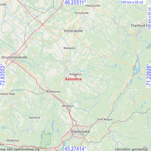
Asbestos GPS coordinates[2]
45° 46' 0.408" North, 71° 55' 56.64" West
| Map corner | latitude | longitude |
|---|---|---|
| Upper-left | 46.25511°, | -72.63553° |
| Center: | 45.76678°, | -71.9324° |
| Lower-right: | 45.27414°, | -71.22928° |
| Map W x H: | 109.1×109.1 km | = 67.8×67.8mi |
| max Lat: | 73.03752° ⇑68.2% North |
| Asbestos: | 45.76678° |
| min Lat: | ⇓31.8% South 42.05009° |
| min Long | Asbestos | max Long |
| -139.43328° | -71.9324° | -52.70931° |
| W 77.1%⇐ | ⇒22.9% E |
Elevation
Elevation of Asbestos is 252 m = 827 ft, and this is 2.4 m = 8 ft below average elevation for this country.
| Max E: |
1518 m = 4980 ft | 35.8% |
| Avg. | 254.4 m = 835 ft | |
| Asbestos | 252 m = 827 ft | |
Min E: |
-2 m = -7 ft | 64.2% |
See also: Canada elevation on elevation.city.
Geographical zone
Asbestos is located in North temperate zone (between Tropic of Cancer and the Arctic Circle). Distance of this North polar circle is 2312.4 km =1436.9 mi to North.| Distance of | km | miles | from Asbestos |
|---|---|---|---|
| North Pole | 4918.3 | 3056.1 | to North |
| Arctic Circle | 2312.4 | 1436.9 | to North |
| Tropic Cancer | 2482.9 | 1542.8 | to South |
| Equator | 5088.8 | 3162 | to South |


Nearby cities:
15 places around Asbestos: (largest is in red/bold)
• Cookshire-Eaton
45.4 km =28.2 mi,  149°
149°
• Danville
6.7 km =4.2 mi,  285°
285°
• Drummondville
44.5 km =27.7 mi, 286°
• East Angus
37.7 km =23.4 mi, 146°
• Kingsey Falls
13.9 km =8.6 mi,  311°
311°
• Princeville
45.2 km =28.1 mi,  5°
5°
• Richmond
20.2 km =12.6 mi,  236°
236°
• Saint-Cyrille-de-Wendover
42.9 km =26.7 mi,  295°
295°
• Saint-Rémi-de-Tingwick
14.3 km =8.9 mi,  39°
39°
• Sherbrooke
40.9 km =25.4 mi,  176°
176°
• Valcourt
42 km =26.1 mi,  225°
225°
• Victoriaville
31.6 km =19.6 mi,  355°
355°
• Warwick
20.7 km =12.9 mi,  349°
349°
• Weedon Centre
37.2 km =23.1 mi,  100°
100°
• Windsor
22.8 km =14.2 mi,  193°
193°
Sources, notices
• [Note1] Compared only with cities in Canada existing in our database
• [Src1] Map data: © OpenStreetMap contributors (CC-BY-SA)
• [Src2] Other city data from geonames.org with taken over terms of usage.
• [Src3] Geographical zone / Annual Mean Temperature by Robert A. Rohde @ Wikipedia
