Sherbrooke geodata
Sherbrooke (Quebec) is a populated place; located in Canada in America/Toronto (GMT-4) time zone. With population of 129,447 people, there are 42 cities with bigger population in this country. Compared to other cities in Canada, 78.5% of cities are located further ↑North; 77.3% of cities are located further ←West and 50.6% of cities have lower elevation than Sherbrooke. Note1


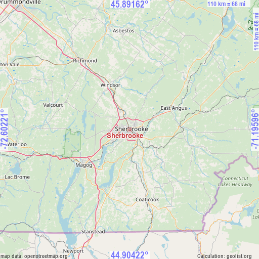
Sherbrooke GPS coordinates[2]
45° 24' 0.288" North, 71° 53' 56.688" West
| Map corner | latitude | longitude |
|---|---|---|
| Upper-left | 45.89162°, | -72.60221° |
| Center: | 45.40008°, | -71.89908° |
| Lower-right: | 44.90422°, | -71.19596° |
| Map W x H: | 109.8×109.8 km | = 68.2×68.2mi |
| max Lat: | 73.03752° ⇑78.5% North |
| Sherbrooke: | 45.40008° |
| min Lat: | ⇓21.5% South 42.05009° |
| min Long | Sherbrooke | max Long |
| -139.43328° | -71.89908° | -52.70931° |
| W 77.3%⇐ | ⇒22.7% E |
Elevation
Elevation of Sherbrooke is 175 m = 574 ft, and this is 79.4 m = 260 ft below average elevation for this country.
| Max E: |
1518 m = 4980 ft | 49.4% |
| Avg. | 254.4 m = 835 ft | |
| Sherbrooke | 175 m = 574 ft | |
Min E: |
-2 m = -7 ft | 50.6% |
See also: Sherbrooke elevation on elevation.city.
Geographical zone
Sherbrooke is located in North temperate zone (between Tropic of Cancer and the Arctic Circle). Distance of this North polar circle is 2353.2 km =1462.2 mi to North.| Distance of | km | miles | from Sherbrooke |
|---|---|---|---|
| North Pole | 4959 | 3081.4 | to North |
| Arctic Circle | 2353.2 | 1462.2 | to North |
| Tropic Cancer | 2442.1 | 1517.5 | to South |
| Equator | 5048 | 3136.7 | to South |


Nearby cities:
15 places around Sherbrooke: (largest is in red/bold)
• Asbestos
40.9 km =25.4 mi,  356°
356°
• Coaticook
30.7 km =19.1 mi,  165°
165°
• Cookshire
21.1 km =13.1 mi,  85°
85°
• Cookshire-Eaton
20.9 km =13 mi,  84°
84°
• Danville
43.6 km =27.1 mi,  347°
347°
• East Angus
20.4 km =12.7 mi,  63°
63°
• Kingsey Falls
51.7 km =32.1 mi, 345°
• Magog
24.5 km =15.2 mi,  232°
232°
• Richmond
35.5 km =22.1 mi,  326°
326°
• Rock Forest
9 km =5.6 mi,  237°
237°
• Rock Island
46.4 km =28.8 mi,  199°
199°
• Valcourt
34.4 km =21.4 mi,  288°
288°
• Waterloo
48.5 km =30.1 mi,  263°
263°
• Weedon Centre
48.4 km =30.1 mi,  44°
44°
• Windsor
20.1 km =12.5 mi,  337°
337°
Sources, notices
• [Note1] Compared only with cities in Canada existing in our database
• [Src1] Map data: © OpenStreetMap contributors (CC-BY-SA)
• [Src2] Other city data from geonames.org with taken over terms of usage.
• [Src3] Geographical zone / Annual Mean Temperature by Robert A. Rohde @ Wikipedia
