East Angus geodata
East Angus (Quebec) is a populated place; located in Canada in America/Toronto (GMT-4) time zone. With population of 3,634 people, there are 559 cities with bigger population in this country. Compared to other cities in Canada, 75.1% of cities are located further ↑North; 78.4% of cities are located further ←West and 54% of cities have lower elevation than East Angus. Note1


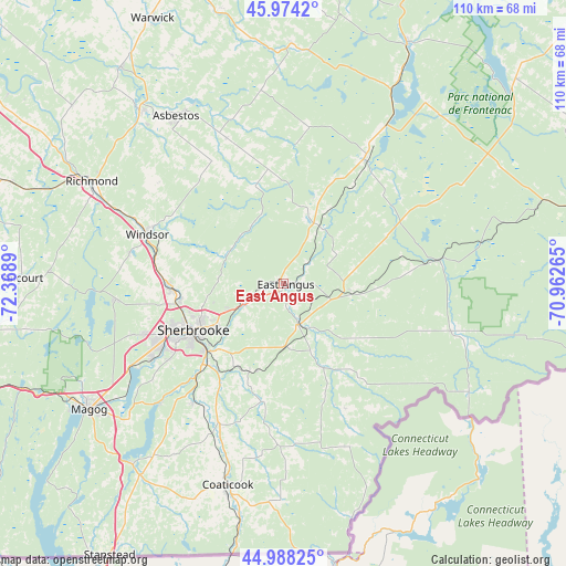
East Angus GPS coordinates[2]
45° 29' 0.168" North, 71° 39' 56.772" West
| Map corner | latitude | longitude |
|---|---|---|
| Upper-left | 45.9742°, | -72.3689° |
| Center: | 45.48338°, | -71.66577° |
| Lower-right: | 44.98825°, | -70.96265° |
| Map W x H: | 109.6×109.6 km | = 68.1×68.1mi |
| max Lat: | 73.03752° ⇑75.1% North |
| East Angus: | 45.48338° |
| min Lat: | ⇓24.9% South 42.05009° |
| min Long | East Angus | max Long |
| -139.43328° | -71.66577° | -52.70931° |
| W 78.4%⇐ | ⇒21.6% E |
Elevation
Elevation of East Angus is 191 m = 627 ft, and this is 63.4 m = 208 ft below average elevation for this country.
| Max E: |
1518 m = 4980 ft | 46% |
| Avg. | 254.4 m = 835 ft | |
| East Angus | 191 m = 627 ft | |
Min E: |
-2 m = -7 ft | 54% |
See also: Canada elevation on elevation.city.
Geographical zone
East Angus is located in North temperate zone (between Tropic of Cancer and the Arctic Circle). Distance of this North polar circle is 2343.9 km =1456.4 mi to North.| Distance of | km | miles | from East Angus |
|---|---|---|---|
| North Pole | 4949.8 | 3075.7 | to North |
| Arctic Circle | 2343.9 | 1456.4 | to North |
| Tropic Cancer | 2451.4 | 1523.2 | to South |
| Equator | 5057.3 | 3142.5 | to South |


Nearby cities:
15 places around East Angus: (largest is in red/bold)
• Asbestos
37.7 km =23.4 mi,  326°
326°
• Coaticook
40.3 km =25 mi,  194°
194°
• Cookshire
8.1 km =5 mi,  159°
159°
• Cookshire-Eaton
7.9 km =4.9 mi, 160°
• Danville
43 km =26.7 mi,  320°
320°
• Disraeli
52.5 km =32.6 mi,  27°
27°
• Kingsey Falls
51.3 km =31.9 mi, 322°
• Magog
44.8 km =27.8 mi,  237°
237°
• Richmond
42.8 km =26.6 mi,  298°
298°
• Rock Forest
29.4 km =18.3 mi, 241°
• Saint-Rémi-de-Tingwick
44.2 km =27.5 mi,  344°
344°
• Sherbrooke
20.4 km =12.7 mi, 243°
• Valcourt
50.7 km =31.5 mi,  272°
272°
• Weedon Centre
29.7 km =18.5 mi, 32°
• Windsor
27.6 km =17.1 mi,  289°
289°
Sources, notices
• [Note1] Compared only with cities in Canada existing in our database
• [Src1] Map data: © OpenStreetMap contributors (CC-BY-SA)
• [Src2] Other city data from geonames.org with taken over terms of usage.
• [Src3] Geographical zone / Annual Mean Temperature by Robert A. Rohde @ Wikipedia
