Binbrook geodata
Binbrook (Ontario) is a section of populated place; located in Canada in America/Toronto (GMT-4) time zone. With population of 8,796 people, there are 343 cities with bigger population in this country. Compared to other cities in Canada, 97% of cities are located further ↑North; 54.5% of cities are located further →East and 57.3% of cities have lower elevation than Binbrook. Note1


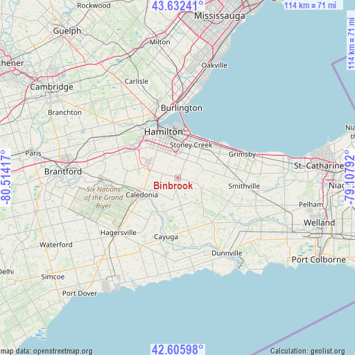
Binbrook GPS coordinates[2]
43° 7' 16.86" North, 79° 48' 39.744" West
| Map corner | latitude | longitude |
|---|---|---|
| Upper-left | 43.63241°, | -80.51417° |
| Center: | 43.12135°, | -79.81104° |
| Lower-right: | 42.60598°, | -79.10792° |
| Map W x H: | 114.1×114.1 km | = 70.9×70.9mi |
| max Lat: | 73.03752° ⇑97% North |
| Binbrook: | 43.12135° |
| min Lat: | ⇓3% South 42.05009° |
| min Long | Binbrook | max Long |
| -139.43328° | -79.81104° | -52.70931° |
| W 45.5%⇐ | ⇒54.5% E |
Elevation
Elevation of Binbrook is 216 m = 709 ft, and this is 38.4 m = 126 ft below average elevation for this country.
| Max E: |
1518 m = 4980 ft | 42.7% |
| Avg. | 254.4 m = 835 ft | |
| Binbrook | 216 m = 709 ft | |
Min E: |
-2 m = -7 ft | 57.3% |
See also: Canada elevation on elevation.city.
Geographical zone
Binbrook is located in North temperate zone (between Tropic of Cancer and the Arctic Circle). Distance of this Northern Tropic circle is 2188.7 km =1360 mi to South.| Distance of | km | miles | from Binbrook |
|---|---|---|---|
| North Pole | 5212.4 | 3238.8 | to North |
| Arctic Circle | 2606.5 | 1619.6 | to North |
| Tropic Cancer | 2188.7 | 1360 | to South |
| Equator | 4794.6 | 2979.2 | to South |


Nearby cities:
15 places around Binbrook: (largest is in red/bold)
• Ancaster
17.9 km =11.1 mi,  306°
306°
• Brant
43.7 km =27.2 mi,  271°
271°
• Brantford
37 km =23 mi, 272°
• Burlington
29.5 km =18.3 mi,  355°
355°
• Cambridge
48.5 km =30.1 mi,  303°
303°
• Hamilton
14.7 km =9.1 mi,  347°
347°
• Jarvis
35.4 km =22 mi,  221°
221°
• Milton
44.4 km =27.6 mi, 352°
• Oakville
38 km =23.6 mi,  15°
15°
• Paris
47.2 km =29.3 mi,  280°
280°
• St. Catharines
46.4 km =28.8 mi,  83°
83°
• St. George
38.3 km =23.8 mi,  291°
291°
• Vineland
33.5 km =20.8 mi, 84°
• Waterford
43.7 km =27.2 mi,  241°
241°
• Welland
48.1 km =29.9 mi,  108°
108°
Sources, notices
• [Note1] Compared only with cities in Canada existing in our database
• [Src1] Map data: © OpenStreetMap contributors (CC-BY-SA)
• [Src2] Other city data from geonames.org with taken over terms of usage.
• [Src3] Geographical zone / Annual Mean Temperature by Robert A. Rohde @ Wikipedia
