Welland geodata
Welland (Ontario) is a populated place; located in Canada in America/Toronto (GMT-4) time zone. With population of 50,331 people, there are 100 cities with bigger population in this country. Compared to other cities in Canada, 97.5% of cities are located further ↑North; 51.1% of cities are located further →East and 51.8% of cities have lower elevation than Welland. Note1


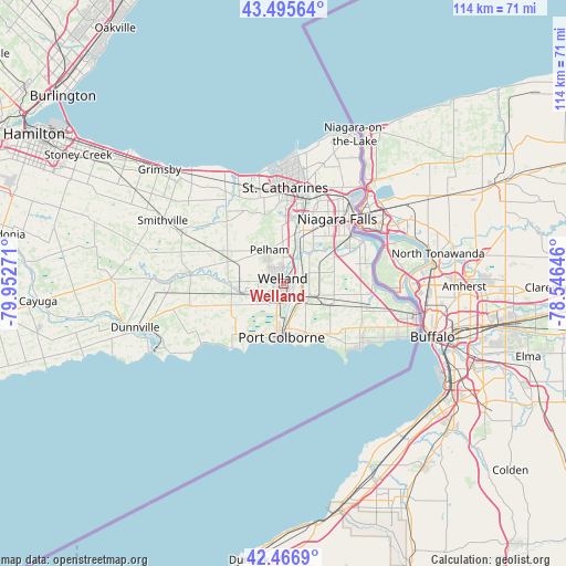
Welland GPS coordinates[2]
42° 59' 0.312" North, 79° 14' 58.488" West
| Map corner | latitude | longitude |
|---|---|---|
| Upper-left | 43.49564°, | -79.95271° |
| Center: | 42.98342°, | -79.24958° |
| Lower-right: | 42.4669°, | -78.54646° |
| Map W x H: | 114.4×114.4 km | = 71.1×71.1mi |
| max Lat: | 73.03752° ⇑97.5% North |
| Welland: | 42.98342° |
| min Lat: | ⇓2.5% South 42.05009° |
| min Long | Welland | max Long |
| -139.43328° | -79.24958° | -52.70931° |
| W 48.9%⇐ | ⇒51.1% E |
Elevation
Elevation of Welland is 180 m = 591 ft, and this is 74.4 m = 244 ft below average elevation for this country.
| Max E: |
1518 m = 4980 ft | 48.2% |
| Avg. | 254.4 m = 835 ft | |
| Welland | 180 m = 591 ft | |
Min E: |
-2 m = -7 ft | 51.8% |
See also: Welland elevation on elevation.city.
Geographical zone
Welland is located in North temperate zone (between Tropic of Cancer and the Arctic Circle). Distance of this Northern Tropic circle is 2173.4 km =1350.5 mi to South.| Distance of | km | miles | from Welland |
|---|---|---|---|
| North Pole | 5227.8 | 3248.4 | to North |
| Arctic Circle | 2621.9 | 1629.2 | to North |
| Tropic Cancer | 2173.4 | 1350.5 | to South |
| Equator | 4779.3 | 2969.7 | to South |


Nearby cities:
15 places around Welland: (largest is in red/bold)
• Ancaster
65.3 km =40.6 mi,  293°
293°
• Binbrook
48.1 km =29.9 mi, 288°
• Burlington
65.4 km =40.6 mi,  313°
313°
• Fort Erie
27.4 km =17 mi,  109°
109°
• Hamilton
57 km =35.4 mi,  301°
301°
• Jarvis
70.1 km =43.6 mi,  260°
260°
• Mississauga Beach
34.3 km =21.3 mi,  23°
23°
• Niagara Falls
19.8 km =12.3 mi,  48°
48°
• Oakville
62.7 km =39 mi,  325°
325°
• Port Colborne
9.4 km =5.8 mi,  171°
171°
• St. Catharines
20.9 km =13 mi,  1°
1°
• Thorold
15.4 km =9.6 mi, 15°
• Thunder Bay
20.9 km =13 mi,  123°
123°
• Vineland
22.2 km =13.8 mi, 326°
• Virgil
27.6 km =17.1 mi, 20°
Sources, notices
• [Note1] Compared only with cities in Canada existing in our database
• [Src1] Map data: © OpenStreetMap contributors (CC-BY-SA)
• [Src2] Other city data from geonames.org with taken over terms of usage.
• [Src3] Geographical zone / Annual Mean Temperature by Robert A. Rohde @ Wikipedia
