Brantford geodata
Brantford (Ontario) is a populated place; located in Canada in America/Toronto (GMT-4) time zone. With population of 87,759 people, there are 64 cities with bigger population in this country. Compared to other cities in Canada, 96.8% of cities are located further ↑North; 56.3% of cities are located further →East and 55% of cities have lower elevation than Brantford. Note1


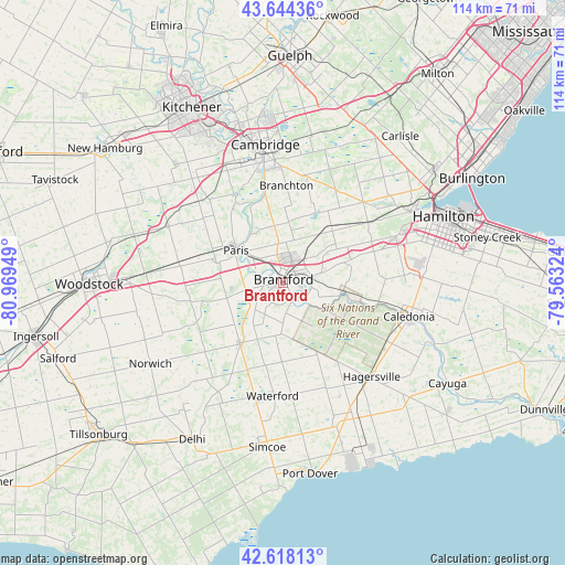
Brantford GPS coordinates[2]
43° 8' 0.24" North, 80° 15' 58.896" West
| Map corner | latitude | longitude |
|---|---|---|
| Upper-left | 43.64436°, | -80.96949° |
| Center: | 43.1334°, | -80.26636° |
| Lower-right: | 42.61813°, | -79.56324° |
| Map W x H: | 114.1×114.1 km | = 70.9×70.9mi |
| max Lat: | 73.03752° ⇑96.8% North |
| Brantford: | 43.1334° |
| min Lat: | ⇓3.2% South 42.05009° |
| min Long | Brantford | max Long |
| -139.43328° | -80.26636° | -52.70931° |
| W 43.7%⇐ | ⇒56.3% E |
Elevation
Elevation of Brantford is 200 m = 656 ft, and this is 54.4 m = 178 ft below average elevation for this country.
| Max E: |
1518 m = 4980 ft | 45% |
| Avg. | 254.4 m = 835 ft | |
| Brantford | 200 m = 656 ft | |
Min E: |
-2 m = -7 ft | 55% |
See also: Brantford elevation on elevation.city.
Geographical zone
Brantford is located in North temperate zone (between Tropic of Cancer and the Arctic Circle). Distance of this Northern Tropic circle is 2190.1 km =1360.9 mi to South.| Distance of | km | miles | from Brantford |
|---|---|---|---|
| North Pole | 5211.1 | 3238 | to North |
| Arctic Circle | 2605.2 | 1618.8 | to North |
| Tropic Cancer | 2190.1 | 1360.9 | to South |
| Equator | 4796 | 2980.1 | to South |


Nearby cities:
15 places around Brantford: (largest is in red/bold)
• Ancaster
24.5 km =15.2 mi,  67°
67°
• Binbrook
37 km =23 mi,  92°
92°
• Brant
6.8 km =4.2 mi,  270°
270°
• Burford
13.6 km =8.5 mi,  255°
255°
• Cambridge
25.5 km =15.8 mi,  351°
351°
• Hamilton
36.2 km =22.5 mi, 68°
• Jarvis
30.9 km =19.2 mi,  154°
154°
• Kitchener
38 km =23.6 mi,  328°
328°
• Norfolk County
34.7 km =21.6 mi,  195°
195°
• Paris
12 km =7.5 mi,  307°
307°
• Plattsville
33.9 km =21.1 mi,  303°
303°
• Simcoe
33.5 km =20.8 mi,  184°
184°
• St. George
12.5 km =7.8 mi,  5°
5°
• Waterford
22.3 km =13.9 mi, 183°
• Woodstock
39.2 km =24.4 mi, 269°
Sources, notices
• [Note1] Compared only with cities in Canada existing in our database
• [Src1] Map data: © OpenStreetMap contributors (CC-BY-SA)
• [Src2] Other city data from geonames.org with taken over terms of usage.
• [Src3] Geographical zone / Annual Mean Temperature by Robert A. Rohde @ Wikipedia
