Etobicoke geodata
Etobicoke (Ontario) is a populated place; located in Canada in America/Toronto (GMT-4) time zone. With population of 347,948 people, there are 16 cities with bigger population in this country. Compared to other cities in Canada, 94% of cities are located further ↑North; 53.6% of cities are located further →East and 54% of cities have higher elevation than Etobicoke. Note1


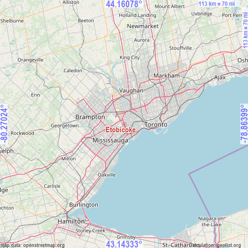
Etobicoke GPS coordinates[2]
43° 39' 15.156" North, 79° 34' 1.596" West
| Map corner | latitude | longitude |
|---|---|---|
| Upper-left | 44.16078°, | -80.27024° |
| Center: | 43.65421°, | -79.56711° |
| Lower-right: | 43.14333°, | -78.86399° |
| Map W x H: | 113.1×113.1 km | = 70.3×70.3mi |
| max Lat: | 73.03752° ⇑94% North |
| Etobicoke: | 43.65421° |
| min Lat: | ⇓6% South 42.05009° |
| min Long | Etobicoke | max Long |
| -139.43328° | -79.56711° | -52.70931° |
| W 46.4%⇐ | ⇒53.6% E |
Elevation
Elevation of Etobicoke is 148 m = 486 ft, and this is 106.4 m = 349 ft below average elevation for this country.
| Max E: |
1518 m = 4980 ft | 54% |
| Avg. | 254.4 m = 835 ft | |
| Etobicoke | 148 m = 486 ft | |
Min E: |
-2 m = -7 ft | 46% |
See also: Etobicoke elevation on elevation.city.
Geographical zone
Etobicoke is located in North temperate zone (between Tropic of Cancer and the Arctic Circle). Distance of this Northern Tropic circle is 2248 km =1396.8 mi to South.| Distance of | km | miles | from Etobicoke |
|---|---|---|---|
| North Pole | 5153.2 | 3202 | to North |
| Arctic Circle | 2547.3 | 1582.8 | to North |
| Tropic Cancer | 2248 | 1396.8 | to South |
| Equator | 4853.9 | 3016.1 | to South |


Nearby cities:
15 places around Etobicoke: (largest is in red/bold)
• Brampton
16.3 km =10.1 mi,  281°
281°
• Burlington
36.9 km =22.9 mi,  216°
216°
• Concord
17.6 km =10.9 mi,  22°
22°
• East York
19.7 km =12.2 mi,  78°
78°
• King
34.6 km =21.5 mi,  356°
356°
• Markham
33.8 km =21 mi,  45°
45°
• Milton
29.7 km =18.5 mi,  239°
239°
• Mississauga
11.1 km =6.9 mi, 221°
• North York
17.4 km =10.8 mi,  44°
44°
• Oakville
24.5 km =15.2 mi,  202°
202°
• Richmond Hill
26.3 km =16.3 mi, 23°
• Scarborough
28.2 km =17.5 mi,  62°
62°
• Toronto
13.2 km =8.2 mi,  67°
67°
• Vaughan
21 km =13 mi, 15°
• Willowdale
18.4 km =11.4 mi, 47°
Sources, notices
• [Note1] Compared only with cities in Canada existing in our database
• [Src1] Map data: © OpenStreetMap contributors (CC-BY-SA)
• [Src2] Other city data from geonames.org with taken over terms of usage.
• [Src3] Geographical zone / Annual Mean Temperature by Robert A. Rohde @ Wikipedia
