Vaughan geodata
Vaughan (Ontario) is a populated place; located in Canada in America/Toronto (GMT-4) time zone. With population of 238,866 people, there are 24 cities with bigger population in this country. Compared to other cities in Canada, 92.8% of cities are located further ↑North; 53.5% of cities are located further →East and 57.9% of cities have lower elevation than Vaughan. Note1


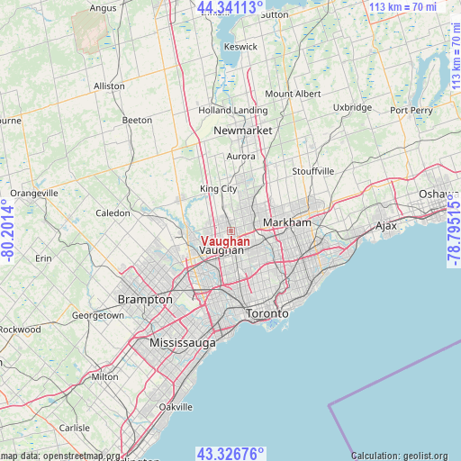
Vaughan GPS coordinates[2]
43° 50' 9.96" North, 79° 29' 53.772" West
| Map corner | latitude | longitude |
|---|---|---|
| Upper-left | 44.34113°, | -80.2014° |
| Center: | 43.8361°, | -79.49827° |
| Lower-right: | 43.32676°, | -78.79515° |
| Map W x H: | 112.8×112.8 km | = 70.1×70.1mi |
| max Lat: | 73.03752° ⇑92.8% North |
| Vaughan: | 43.8361° |
| min Lat: | ⇓7.2% South 42.05009° |
| min Long | Vaughan | max Long |
| -139.43328° | -79.49827° | -52.70931° |
| W 46.5%⇐ | ⇒53.5% E |
Elevation
Elevation of Vaughan is 218 m = 715 ft, and this is 36.4 m = 119 ft below average elevation for this country.
| Max E: |
1518 m = 4980 ft | 42.1% |
| Avg. | 254.4 m = 835 ft | |
| Vaughan | 218 m = 715 ft | |
Min E: |
-2 m = -7 ft | 57.9% |
See also: Vaughan elevation on elevation.city.
Geographical zone
Vaughan is located in North temperate zone (between Tropic of Cancer and the Arctic Circle). Distance of this Northern Tropic circle is 2268.2 km =1409.4 mi to South.| Distance of | km | miles | from Vaughan |
|---|---|---|---|
| North Pole | 5132.9 | 3189.4 | to North |
| Arctic Circle | 2527.1 | 1570.3 | to North |
| Tropic Cancer | 2268.2 | 1409.4 | to South |
| Equator | 4874.1 | 3028.6 | to South |


Nearby cities:
15 places around Vaughan: (largest is in red/bold)
• Aurora
18.4 km =11.4 mi,  7°
7°
• Ballantrae
27.1 km =16.8 mi,  35°
35°
• Brampton
27.4 km =17 mi,  231°
231°
• Concord
4.2 km =2.6 mi,  162°
162°
• East Gwillimbury
29.8 km =18.5 mi, 9°
• East York
21.2 km =13.2 mi,  139°
139°
• Etobicoke
21 km =13 mi,  195°
195°
• King
16.1 km =10 mi,  332°
332°
• Markham
18.9 km =11.7 mi,  79°
79°
• Newmarket
23.9 km =14.9 mi, 6°
• North York
10.1 km =6.3 mi, 139°
• Richmond Hill
6.3 km =3.9 mi,  51°
51°
• Scarborough
20.6 km =12.8 mi,  110°
110°
• Toronto
16.5 km =10.3 mi, 156°
• Willowdale
11.1 km =6.9 mi,  134°
134°
Sources, notices
• [Note1] Compared only with cities in Canada existing in our database
• [Src1] Map data: © OpenStreetMap contributors (CC-BY-SA)
• [Src2] Other city data from geonames.org with taken over terms of usage.
• [Src3] Geographical zone / Annual Mean Temperature by Robert A. Rohde @ Wikipedia
