Fall River geodata
Fall River (Nova Scotia) is a populated place; located in Canada in America/Halifax (GMT-3) time zone. With population of 11,526 people, there are 286 cities with bigger population in this country. Compared to other cities in Canada, 85.5% of cities are located further ↑North; 94.6% of cities are located further ←West and 79.4% of cities have higher elevation than Fall River. Note1


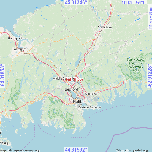
Fall River GPS coordinates[2]
44° 49' 0.66" North, 63° 36' 55.44" West
| Map corner | latitude | longitude |
|---|---|---|
| Upper-left | 45.31346°, | -64.31853° |
| Center: | 44.81685°, | -63.6154° |
| Lower-right: | 44.31592°, | -62.91228° |
| Map W x H: | 110.9×110.9 km | = 68.9×68.9mi |
| max Lat: | 73.03752° ⇑85.5% North |
| Fall River: | 44.81685° |
| min Lat: | ⇓14.5% South 42.05009° |
| min Long | Fall River | max Long |
| -139.43328° | -63.6154° | -52.70931° |
| W 94.6%⇐ | ⇒5.4% E |
Elevation
Elevation of Fall River is 33 m = 108 ft, and this is 221.4 m = 726 ft below average elevation for this country.
| Max E: |
1518 m = 4980 ft | 79.4% |
| Avg. | 254.4 m = 835 ft | |
| Fall River | 33 m = 108 ft | |
Min E: |
-2 m = -7 ft | 20.6% |
See also: Canada elevation on elevation.city.
Geographical zone
Fall River is located in North temperate zone (between Tropic of Cancer and the Arctic Circle). Distance of this Northern Tropic circle is 2377.2 km =1477.1 mi to South.| Distance of | km | miles | from Fall River |
|---|---|---|---|
| North Pole | 5023.9 | 3121.7 | to North |
| Arctic Circle | 2418 | 1502.5 | to North |
| Tropic Cancer | 2377.2 | 1477.1 | to South |
| Equator | 4983.2 | 3096.4 | to South |


Nearby cities:
15 places around Fall River: (largest is in red/bold)
• Boutiliers Point
31.4 km =19.5 mi,  237°
237°
• Chester
58 km =36 mi, 238°
• Cole Harbour
19.5 km =12.1 mi,  145°
145°
• Cow Bay
25.2 km =15.7 mi,  144°
144°
• Dartmouth
16.5 km =10.3 mi,  169°
169°
• English Corner
16.1 km =10 mi,  234°
234°
• Halifax
19.4 km =12.1 mi, 169°
• Hantsport
51.4 km =31.9 mi,  302°
302°
• Lake Echo
20.6 km =12.8 mi,  116°
116°
• Lantz
21.3 km =13.2 mi,  29°
29°
• Lower Sackville
6.7 km =4.2 mi, 227°
• Terence Bay
39.5 km =24.5 mi,  192°
192°
• Waverley
3.9 km =2.4 mi,  160°
160°
• Windsor
44.7 km =27.8 mi,  294°
294°
• Wolfville
66 km =41 mi, 296°
Sources, notices
• [Note1] Compared only with cities in Canada existing in our database
• [Src1] Map data: © OpenStreetMap contributors (CC-BY-SA)
• [Src2] Other city data from geonames.org with taken over terms of usage.
• [Src3] Geographical zone / Annual Mean Temperature by Robert A. Rohde @ Wikipedia
