Lantz geodata
Lantz (Nova Scotia) is a populated place; located in Canada in America/Halifax (GMT-3) time zone. With population of 2,229 people, there are 712 cities with bigger population in this country. Compared to other cities in Canada, 84.9% of cities are located further ↑North; 95% of cities are located further ←West and 86.8% of cities have higher elevation than Lantz. Note1


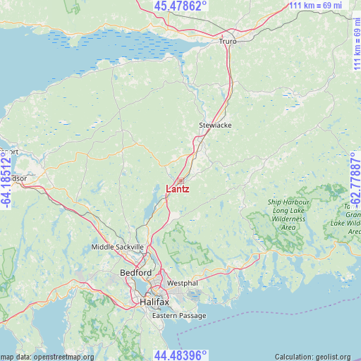
Lantz GPS coordinates[2]
44° 59' 0.42" North, 63° 28' 55.164" West
| Map corner | latitude | longitude |
|---|---|---|
| Upper-left | 45.47862°, | -64.18512° |
| Center: | 44.98345°, | -63.48199° |
| Lower-right: | 44.48396°, | -62.77887° |
| Map W x H: | 110.6×110.6 km | = 68.7×68.7mi |
| max Lat: | 73.03752° ⇑84.9% North |
| Lantz: | 44.98345° |
| min Lat: | ⇓15.1% South 42.05009° |
| min Long | Lantz | max Long |
| -139.43328° | -63.48199° | -52.70931° |
| W 95%⇐ | ⇒5% E |
Elevation
Elevation of Lantz is 18 m = 59 ft, and this is 236.4 m = 776 ft below average elevation for this country.
| Max E: |
1518 m = 4980 ft | 86.8% |
| Avg. | 254.4 m = 835 ft | |
| Lantz | 18 m = 59 ft | |
Min E: |
-2 m = -7 ft | 13.2% |
See also: Canada elevation on elevation.city.
Geographical zone
Lantz is located in North temperate zone (between Tropic of Cancer and the Arctic Circle). Distance of this Northern Tropic circle is 2395.8 km =1488.7 mi to South.| Distance of | km | miles | from Lantz |
|---|---|---|---|
| North Pole | 5005.4 | 3110.2 | to North |
| Arctic Circle | 2399.5 | 1491 | to North |
| Tropic Cancer | 2395.8 | 1488.7 | to South |
| Equator | 5001.7 | 3107.9 | to South |


Nearby cities:
15 places around Lantz: (largest is in red/bold)
• Boutiliers Point
51.1 km =31.8 mi,  226°
226°
• Cole Harbour
34.6 km =21.5 mi,  179°
179°
• Cow Bay
39.3 km =24.4 mi,  174°
174°
• Dartmouth
35.5 km =22.1 mi,  192°
192°
• English Corner
36.5 km =22.7 mi,  220°
220°
• Fall River
21.3 km =13.2 mi,  209°
209°
• Halifax
38.3 km =23.8 mi, 190°
• Hantsport
54.5 km =33.9 mi,  279°
279°
• Lake Echo
28.9 km =18 mi,  164°
164°
• Lower Sackville
27.8 km =17.3 mi, 213°
• Terence Bay
60.1 km =37.3 mi,  198°
198°
• Truro
45.9 km =28.5 mi,  21°
21°
• Waverley
24.1 km =15 mi, 202°
• Windsor
51.1 km =31.8 mi,  270°
270°
• Wolfville
70.3 km =43.7 mi, 279°
Sources, notices
• [Note1] Compared only with cities in Canada existing in our database
• [Src1] Map data: © OpenStreetMap contributors (CC-BY-SA)
• [Src2] Other city data from geonames.org with taken over terms of usage.
• [Src3] Geographical zone / Annual Mean Temperature by Robert A. Rohde @ Wikipedia
