Lunenburg geodata
Lunenburg (Nova Scotia) is a populated place; located in Canada in America/Halifax (GMT-3) time zone. With population of 2,085 people, there are 734 cities with bigger population in this country. Compared to other cities in Canada, 88.3% of cities are located further ↑North; 93.3% of cities are located further ←West and 93.8% of cities have higher elevation than Lunenburg. Note1


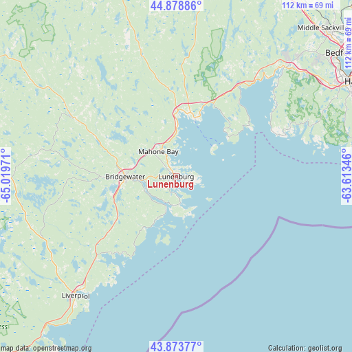
Lunenburg GPS coordinates[2]
44° 22' 42.492" North, 64° 18' 59.688" West
| Map corner | latitude | longitude |
|---|---|---|
| Upper-left | 44.87886°, | -65.01971° |
| Center: | 44.37847°, | -64.31658° |
| Lower-right: | 43.87377°, | -63.61346° |
| Map W x H: | 111.8×111.8 km | = 69.5×69.5mi |
| max Lat: | 73.03752° ⇑88.3% North |
| Lunenburg: | 44.37847° |
| min Lat: | ⇓11.7% South 42.05009° |
| min Long | Lunenburg | max Long |
| -139.43328° | -64.31658° | -52.70931° |
| W 93.3%⇐ | ⇒6.7% E |
Elevation
Elevation of Lunenburg is 10 m = 33 ft, and this is 244.4 m = 802 ft below average elevation for this country.
| Max E: |
1518 m = 4980 ft | 93.8% |
| Avg. | 254.4 m = 835 ft | |
| Lunenburg | 10 m = 33 ft | |
Min E: |
-2 m = -7 ft | 6.2% |
See also: Canada elevation on elevation.city.
Geographical zone
Lunenburg is located in North temperate zone (between Tropic of Cancer and the Arctic Circle). Distance of this Northern Tropic circle is 2328.5 km =1446.9 mi to South.| Distance of | km | miles | from Lunenburg |
|---|---|---|---|
| North Pole | 5072.6 | 3152 | to North |
| Arctic Circle | 2466.8 | 1532.8 | to North |
| Tropic Cancer | 2328.5 | 1446.9 | to South |
| Equator | 4934.4 | 3066.1 | to South |


Nearby cities:
15 places around Lunenburg: (largest is in red/bold)
• Boutiliers Point
43.1 km =26.8 mi,  42°
42°
• Bridgewater
16.1 km =10 mi,  270°
270°
• Chester
19.2 km =11.9 mi,  18°
18°
• Cole Harbour
74.3 km =46.2 mi,  63°
63°
• Cow Bay
75.6 km =47 mi,  68°
68°
• Dartmouth
67.1 km =41.7 mi, 60°
• English Corner
57.9 km =36 mi,  47°
47°
• Fall River
73.9 km =45.9 mi, 48°
• Halifax
66 km =41 mi, 63°
• Hantsport
77.5 km =48.2 mi,  8°
8°
• Hayes Subdivision
78.2 km =48.6 mi,  344°
344°
• Lower Sackville
67.1 km =41.7 mi, 48°
• Terence Bay
48.3 km =30 mi,  77°
77°
• Waverley
72.5 km =45 mi, 51°
• Windsor
68.8 km =42.8 mi, 12°
Sources, notices
• [Note1] Compared only with cities in Canada existing in our database
• [Src1] Map data: © OpenStreetMap contributors (CC-BY-SA)
• [Src2] Other city data from geonames.org with taken over terms of usage.
• [Src3] Geographical zone / Annual Mean Temperature by Robert A. Rohde @ Wikipedia
