Mercier geodata
Mercier (Quebec) is a populated place; located in Canada in America/Toronto (GMT-4) time zone. With population of 10,121 people, there are 308 cities with bigger population in this country. Compared to other cities in Canada, 80.5% of cities are located further ↑North; 65.3% of cities are located further ←West and 73.7% of cities have higher elevation than Mercier. Note1


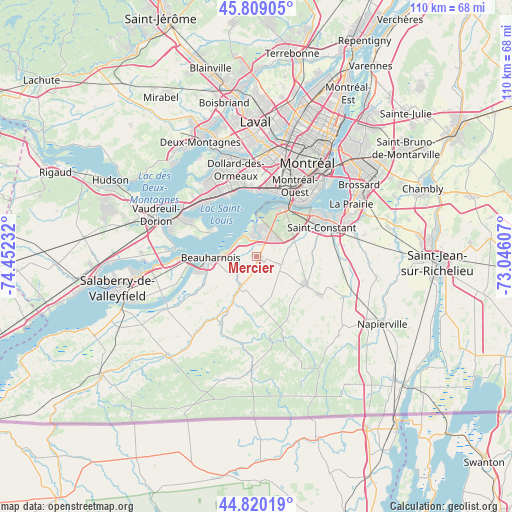
Mercier GPS coordinates[2]
45° 19' 0.408" North, 73° 44' 57.084" West
| Map corner | latitude | longitude |
|---|---|---|
| Upper-left | 45.80905°, | -74.45232° |
| Center: | 45.31678°, | -73.74919° |
| Lower-right: | 44.82019°, | -73.04607° |
| Map W x H: | 110×109.9 km | = 68.4×68.3mi |
| max Lat: | 73.03752° ⇑80.5% North |
| Mercier: | 45.31678° |
| min Lat: | ⇓19.5% South 42.05009° |
| min Long | Mercier | max Long |
| -139.43328° | -73.74919° | -52.70931° |
| W 65.3%⇐ | ⇒34.7% E |
Elevation
Elevation of Mercier is 47 m = 154 ft, and this is 207.4 m = 680 ft below average elevation for this country.
| Max E: |
1518 m = 4980 ft | 73.7% |
| Avg. | 254.4 m = 835 ft | |
| Mercier | 47 m = 154 ft | |
Min E: |
-2 m = -7 ft | 26.3% |
See also: Canada elevation on elevation.city.
Geographical zone
Mercier is located in North temperate zone (between Tropic of Cancer and the Arctic Circle). Distance of this North polar circle is 2362.4 km =1467.9 mi to North.| Distance of | km | miles | from Mercier |
|---|---|---|---|
| North Pole | 4968.3 | 3087.2 | to North |
| Arctic Circle | 2362.4 | 1467.9 | to North |
| Tropic Cancer | 2432.8 | 1511.7 | to South |
| Equator | 5038.8 | 3131 | to South |


Nearby cities:
15 places around Mercier: (largest is in red/bold)
• Baie-D'Urfé
16.9 km =10.5 mi,  309°
309°
• Beaconsfield
15.8 km =9.8 mi,  324°
324°
• Beauharnois
9.6 km =6 mi,  267°
267°
• Châteauguay
7.4 km =4.6 mi,  0°
0°
• Delson
16.6 km =10.3 mi,  70°
70°
• Dorval
14.5 km =9 mi,  358°
358°
• L'Île-Perrot
17.3 km =10.7 mi,  295°
295°
• Melocheville
14.7 km =9.1 mi, 270°
• Montréal-Ouest
17 km =10.6 mi,  27°
27°
• Notre-Dame-de-l'Île-Perrot
15.4 km =9.6 mi,  291°
291°
• Pointe-Claire
15.6 km =9.7 mi,  340°
340°
• Saint-Constant
15.4 km =9.6 mi, 68°
• Saint-Rémi
11.8 km =7.3 mi,  118°
118°
• Sainte-Catherine
16 km =9.9 mi,  54°
54°
• Sainte-Martine
8.4 km =5.2 mi,  207°
207°
Sources, notices
• [Note1] Compared only with cities in Canada existing in our database
• [Src1] Map data: © OpenStreetMap contributors (CC-BY-SA)
• [Src2] Other city data from geonames.org with taken over terms of usage.
• [Src3] Geographical zone / Annual Mean Temperature by Robert A. Rohde @ Wikipedia
