Sainte-Martine geodata
Sainte-Martine (Quebec) is a populated place; located in Canada in America/Toronto (GMT-4) time zone. With population of 2,535 people, there are 670 cities with bigger population in this country. Compared to other cities in Canada, 82% of cities are located further ↑North; 64.7% of cities are located further ←West and 79.4% of cities have higher elevation than Sainte-Martine. Note1


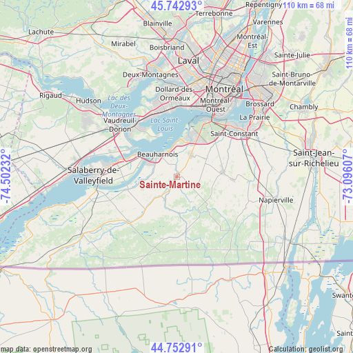
Sainte-Martine GPS coordinates[2]
45° 15' 0.288" North, 73° 47' 57.084" West
| Map corner | latitude | longitude |
|---|---|---|
| Upper-left | 45.74293°, | -74.50232° |
| Center: | 45.25008°, | -73.79919° |
| Lower-right: | 44.75291°, | -73.09607° |
| Map W x H: | 110.1×110.1 km | = 68.4×68.4mi |
| max Lat: | 73.03752° ⇑82% North |
| Sainte-Martine: | 45.25008° |
| min Lat: | ⇓18% South 42.05009° |
| min Long | Sainte-Martine | max Long |
| -139.43328° | -73.79919° | -52.70931° |
| W 64.7%⇐ | ⇒35.3% E |
Elevation
Elevation of Sainte-Martine is 33 m = 108 ft, and this is 221.4 m = 726 ft below average elevation for this country.
| Max E: |
1518 m = 4980 ft | 79.4% |
| Avg. | 254.4 m = 835 ft | |
| Sainte-Martine | 33 m = 108 ft | |
Min E: |
-2 m = -7 ft | 20.6% |
See also: Canada elevation on elevation.city.
Geographical zone
Sainte-Martine is located in North temperate zone (between Tropic of Cancer and the Arctic Circle). Distance of this North polar circle is 2369.8 km =1472.5 mi to North.| Distance of | km | miles | from Sainte-Martine |
|---|---|---|---|
| North Pole | 4975.7 | 3091.8 | to North |
| Arctic Circle | 2369.8 | 1472.5 | to North |
| Tropic Cancer | 2425.4 | 1507.1 | to South |
| Equator | 5031.3 | 3126.3 | to South |


Nearby cities:
15 places around Sainte-Martine: (largest is in red/bold)
• Baie-D'Urfé
20.4 km =12.7 mi,  333°
333°
• Beaconsfield
21 km =13 mi,  345°
345°
• Beauharnois
9.1 km =5.7 mi,  320°
320°
• Châteauguay
15.3 km =9.5 mi,  14°
14°
• L'Île-Perrot
18.9 km =11.7 mi, 321°
• Les Cèdres
20.3 km =12.6 mi,  285°
285°
• Melocheville
13.1 km =8.1 mi,  304°
304°
• Mercier
8.4 km =5.2 mi,  27°
27°
• Notre-Dame-de-l'Île-Perrot
16.6 km =10.3 mi, 321°
• Ormstown
20.3 km =12.6 mi,  230°
230°
• Pincourt
20.6 km =12.8 mi, 315°
• Pointe-Claire
22.1 km =13.7 mi,  356°
356°
• Saint-Jean-Baptiste
22.1 km =13.7 mi,  311°
311°
• Saint-Rémi
14.5 km =9 mi,  82°
82°
• Sainte-Anne-de-Bellevue
20.8 km =12.9 mi, 326°
Sources, notices
• [Note1] Compared only with cities in Canada existing in our database
• [Src1] Map data: © OpenStreetMap contributors (CC-BY-SA)
• [Src2] Other city data from geonames.org with taken over terms of usage.
• [Src3] Geographical zone / Annual Mean Temperature by Robert A. Rohde @ Wikipedia
