L'Île-Perrot geodata
L'Île-Perrot (Quebec) is a populated place; located in Canada in America/Toronto (GMT-4) time zone. With population of 9,927 people, there are 313 cities with bigger population in this country. Compared to other cities in Canada, 78.9% of cities are located further ↑North; 62.9% of cities are located further ←West and 72.4% of cities have higher elevation than L'Île-Perrot. Note1


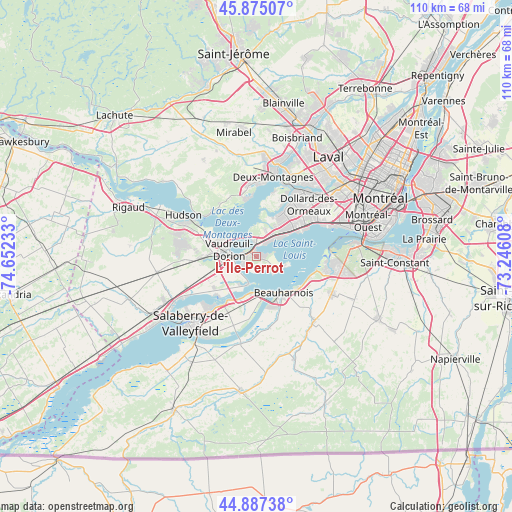
L'Île-Perrot GPS coordinates[2]
45° 23' 0.168" North, 73° 56' 57.12" West
| Map corner | latitude | longitude |
|---|---|---|
| Upper-left | 45.87507°, | -74.65233° |
| Center: | 45.38338°, | -73.9492° |
| Lower-right: | 44.88738°, | -73.24608° |
| Map W x H: | 109.8×109.8 km | = 68.2×68.2mi |
| max Lat: | 73.03752° ⇑78.9% North |
| L'Île-Perrot: | 45.38338° |
| min Lat: | ⇓21.1% South 42.05009° |
| min Long | L'Île-Perrot | max Long |
| -139.43328° | -73.9492° | -52.70931° |
| W 62.9%⇐ | ⇒37.1% E |
Elevation
Elevation of L'Île-Perrot is 49 m = 161 ft, and this is 205.4 m = 674 ft below average elevation for this country.
| Max E: |
1518 m = 4980 ft | 72.4% |
| Avg. | 254.4 m = 835 ft | |
| L'Île-Perrot | 49 m = 161 ft | |
Min E: |
-2 m = -7 ft | 27.6% |
See also: Canada elevation on elevation.city.
Geographical zone
L'Île-Perrot is located in North temperate zone (between Tropic of Cancer and the Arctic Circle). Distance of this North polar circle is 2355 km =1463.3 mi to North.| Distance of | km | miles | from L'Île-Perrot |
|---|---|---|---|
| North Pole | 4960.9 | 3082.6 | to North |
| Arctic Circle | 2355 | 1463.3 | to North |
| Tropic Cancer | 2440.2 | 1516.3 | to South |
| Equator | 5046.2 | 3135.6 | to South |


Nearby cities:
15 places around L'Île-Perrot: (largest is in red/bold)
• Baie-D'Urfé
4.3 km =2.7 mi,  37°
37°
• Beaconsfield
8.6 km =5.3 mi,  49°
49°
• Beauharnois
9.8 km =6.1 mi,  142°
142°
• Kirkland
9.9 km =6.2 mi, 41°
• Les Cèdres
12.1 km =7.5 mi,  220°
220°
• Melocheville
7.4 km =4.6 mi,  172°
172°
• Notre-Dame-de-l'Île-Perrot
2.3 km =1.4 mi, 144°
• Oka
14.2 km =8.8 mi,  309°
309°
• Pincourt
2.6 km =1.6 mi,  270°
270°
• Pointe-Calumet
13 km =8.1 mi,  354°
354°
• Pointe-Claire
12.6 km =7.8 mi, 54°
• Saint-Jean-Baptiste
4.9 km =3 mi, 266°
• Saint-Lazare
14.4 km =8.9 mi,  277°
277°
• Sainte-Anne-de-Bellevue
2.6 km =1.6 mi,  6°
6°
• Vaudreuil-Dorion
6.8 km =4.2 mi,  285°
285°
Sources, notices
• [Note1] Compared only with cities in Canada existing in our database
• [Src1] Map data: © OpenStreetMap contributors (CC-BY-SA)
• [Src2] Other city data from geonames.org with taken over terms of usage.
• [Src3] Geographical zone / Annual Mean Temperature by Robert A. Rohde @ Wikipedia
