Moncton geodata
Moncton (New Brunswick) is a populated place; located in Canada in America/Moncton (GMT-3) time zone. With population of 108,620 people, there are 50 cities with bigger population in this country. Compared to other cities in Canada, 61% of cities are located further ↑North; 91.2% of cities are located further ←West and 81.3% of cities have higher elevation than Moncton. Note1


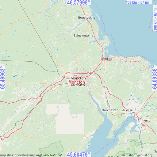
Moncton GPS coordinates[2]
46° 5' 40.344" North, 64° 47' 47.4" West
| Map corner | latitude | longitude |
|---|---|---|
| Upper-left | 46.57998°, | -65.49963° |
| Center: | 46.09454°, | -64.7965° |
| Lower-right: | 45.60479°, | -64.09338° |
| Map W x H: | 108.4×108.4 km | = 67.4×67.4mi |
| max Lat: | 73.03752° ⇑61% North |
| Moncton: | 46.09454° |
| min Lat: | ⇓39% South 42.05009° |
| min Long | Moncton | max Long |
| -139.43328° | -64.7965° | -52.70931° |
| W 91.2%⇐ | ⇒8.8% E |
Elevation
Elevation of Moncton is 30 m = 98 ft, and this is 224.4 m = 736 ft below average elevation for this country.
| Max E: |
1518 m = 4980 ft | 81.3% |
| Avg. | 254.4 m = 835 ft | |
| Moncton | 30 m = 98 ft | |
Min E: |
-2 m = -7 ft | 18.7% |
See also: Moncton elevation on elevation.city.
Geographical zone
Moncton is located in North temperate zone (between Tropic of Cancer and the Arctic Circle). Distance of this North polar circle is 2275.9 km =1414.2 mi to North.| Distance of | km | miles | from Moncton |
|---|---|---|---|
| North Pole | 4881.8 | 3033.4 | to North |
| Arctic Circle | 2275.9 | 1414.2 | to North |
| Tropic Cancer | 2519.3 | 1565.4 | to South |
| Equator | 5125.2 | 3184.7 | to South |


Nearby cities:
15 places around Moncton: (largest is in red/bold)
• Bouctouche
41.8 km =26 mi,  6°
6°
• Dieppe
8.6 km =5.3 mi,  102°
102°
• Evergreen Park
5.6 km =3.5 mi,  291°
291°
• Grande-Digue
29 km =18 mi,  37°
37°
• Greater Lakeburn
10.1 km =6.3 mi, 101°
• Haute-Aboujagane
31.2 km =19.4 mi,  78°
78°
• Lutes Mountain
9.5 km =5.9 mi,  298°
298°
• McEwen
5.7 km =3.5 mi, 8°
• Point de Bute
48 km =29.8 mi,  116°
116°
• Sackville
37.3 km =23.2 mi, 121°
• Saint-Antoine
30.1 km =18.7 mi, 6°
• Salisbury
20.2 km =12.6 mi,  252°
252°
• Shediac
24.1 km =15 mi,  54°
54°
• Shediac Bridge-Shediac River
24.6 km =15.3 mi, 37°
• Shediac Cape
23.6 km =14.7 mi, 49°
Sources, notices
• [Note1] Compared only with cities in Canada existing in our database
• [Src1] Map data: © OpenStreetMap contributors (CC-BY-SA)
• [Src2] Other city data from geonames.org with taken over terms of usage.
• [Src3] Geographical zone / Annual Mean Temperature by Robert A. Rohde @ Wikipedia
