Saint-Édouard geodata
Saint-Édouard (Quebec) is a populated place; located in Canada in America/Toronto (GMT-4) time zone. With population of 1,672 people, there are 819 cities with bigger population in this country. Compared to other cities in Canada, 82.2% of cities are located further ↑North; 67.8% of cities are located further ←West and 70.8% of cities have higher elevation than Saint-Édouard. Note1


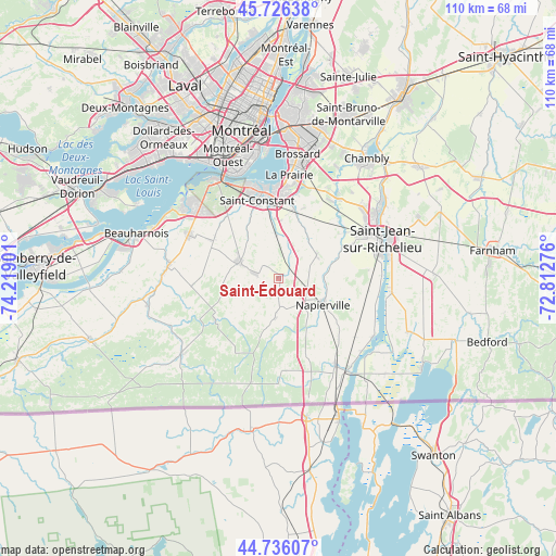
Saint-Édouard GPS coordinates[2]
45° 14' 0.168" North, 73° 30' 57.168" West
| Map corner | latitude | longitude |
|---|---|---|
| Upper-left | 45.72638°, | -74.21901° |
| Center: | 45.23338°, | -73.51588° |
| Lower-right: | 44.73607°, | -72.81276° |
| Map W x H: | 110.1×110.1 km | = 68.4×68.4mi |
| max Lat: | 73.03752° ⇑82.2% North |
| Saint-Édouard: | 45.23338° |
| min Lat: | ⇓17.8% South 42.05009° |
| min Long | Saint-Édouard | max Long |
| -139.43328° | -73.51588° | -52.70931° |
| W 67.8%⇐ | ⇒32.2% E |
Elevation
Elevation of Saint-Édouard is 53 m = 174 ft, and this is 201.4 m = 661 ft below average elevation for this country.
| Max E: |
1518 m = 4980 ft | 70.8% |
| Avg. | 254.4 m = 835 ft | |
| Saint-Édouard | 53 m = 174 ft | |
Min E: |
-2 m = -7 ft | 29.2% |
See also: Canada elevation on elevation.city.
Geographical zone
Saint-Édouard is located in North temperate zone (between Tropic of Cancer and the Arctic Circle). Distance of this North polar circle is 2371.7 km =1473.7 mi to North.| Distance of | km | miles | from Saint-Édouard |
|---|---|---|---|
| North Pole | 4977.6 | 3092.9 | to North |
| Arctic Circle | 2371.7 | 1473.7 | to North |
| Tropic Cancer | 2423.6 | 1506 | to South |
| Equator | 5029.5 | 3125.2 | to South |


Nearby cities:
15 places around Saint-Édouard: (largest is in red/bold)
• Candiac
16.7 km =10.4 mi,  0°
0°
• Delson
15.1 km =9.4 mi,  350°
350°
• Hemmingford
21 km =13 mi,  194°
194°
• La Prairie
20.4 km =12.7 mi, 3°
• Lacolle
20.4 km =12.7 mi,  144°
144°
• Mercier
20.5 km =12.7 mi,  296°
296°
• Napierville
10.2 km =6.3 mi,  120°
120°
• Parc-Boutin
20.9 km =13 mi,  71°
71°
• Saint-Constant
15.3 km =9.5 mi, 345°
• Saint-Jacques-le-Mineur
9.6 km =6 mi,  54°
54°
• Saint-Jean-sur-Richelieu
21.4 km =13.3 mi, 67°
• Saint-Mathieu
9.3 km =5.8 mi, 0°
• Saint-Philippe-de-La Prairie
14.1 km =8.8 mi,  12°
12°
• Saint-Rémi
8.7 km =5.4 mi, 295°
• Sainte-Catherine
19.3 km =12 mi,  344°
344°
Sources, notices
• [Note1] Compared only with cities in Canada existing in our database
• [Src1] Map data: © OpenStreetMap contributors (CC-BY-SA)
• [Src2] Other city data from geonames.org with taken over terms of usage.
• [Src3] Geographical zone / Annual Mean Temperature by Robert A. Rohde @ Wikipedia
