Hemmingford geodata
Hemmingford (Quebec) is a populated place; located in Canada in America/Toronto (GMT-4) time zone. With population of 808 people, there are 1099 cities with bigger population in this country. Compared to other cities in Canada, 84.4% of cities are located further ↑North; 67.2% of cities are located further ←West and 64.5% of cities have higher elevation than Hemmingford. Note1


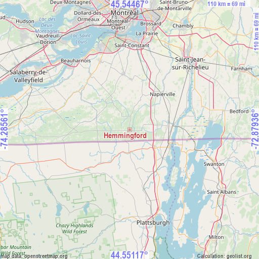
Hemmingford GPS coordinates[2]
45° 3' 0.288" North, 73° 34' 56.928" West
| Map corner | latitude | longitude |
|---|---|---|
| Upper-left | 45.54467°, | -74.28561° |
| Center: | 45.05008°, | -73.58248° |
| Lower-right: | 44.55117°, | -72.87936° |
| Map W x H: | 110.5×110.5 km | = 68.7×68.7mi |
| max Lat: | 73.03752° ⇑84.4% North |
| Hemmingford: | 45.05008° |
| min Lat: | ⇓15.6% South 42.05009° |
| min Long | Hemmingford | max Long |
| -139.43328° | -73.58248° | -52.70931° |
| W 67.2%⇐ | ⇒32.8% E |
Elevation
Elevation of Hemmingford is 79 m = 259 ft, and this is 175.4 m = 575 ft below average elevation for this country.
| Max E: |
1518 m = 4980 ft | 64.5% |
| Avg. | 254.4 m = 835 ft | |
| Hemmingford | 79 m = 259 ft | |
Min E: |
-2 m = -7 ft | 35.5% |
See also: Canada elevation on elevation.city.
Geographical zone
Hemmingford is located in North temperate zone (between Tropic of Cancer and the Arctic Circle). Distance of this North polar circle is 2392.1 km =1486.4 mi to North.| Distance of | km | miles | from Hemmingford |
|---|---|---|---|
| North Pole | 4998 | 3105.6 | to North |
| Arctic Circle | 2392.1 | 1486.4 | to North |
| Tropic Cancer | 2403.2 | 1493.3 | to South |
| Equator | 5009.1 | 3112.5 | to South |


Nearby cities:
15 places around Hemmingford: (largest is in red/bold)
• Delson
35.3 km =21.9 mi,  4°
4°
• Franklin
26.3 km =16.3 mi,  265°
265°
• Lacolle
17.4 km =10.8 mi,  77°
77°
• Mercier
32.4 km =20.1 mi,  336°
336°
• Napierville
20.6 km =12.8 mi,  42°
42°
• Ormstown
34 km =21.1 mi,  285°
285°
• Parc-Boutin
36.8 km =22.9 mi, 43°
• Saint-Constant
35.2 km =21.9 mi, 2°
• Saint-Jacques-le-Mineur
29 km =18 mi,  26°
26°
• Saint-Mathieu
30.1 km =18.7 mi,  9°
9°
• Saint-Philippe-de-La Prairie
35.1 km =21.8 mi, 13°
• Saint-Rémi
24.2 km =15 mi,  353°
353°
• Saint-Édouard
21 km =13 mi, 14°
• Sainte-Martine
28 km =17.4 mi,  322°
322°
• Venise-en-Québec
35.5 km =22.1 mi, 84°
Sources, notices
• [Note1] Compared only with cities in Canada existing in our database
• [Src1] Map data: © OpenStreetMap contributors (CC-BY-SA)
• [Src2] Other city data from geonames.org with taken over terms of usage.
• [Src3] Geographical zone / Annual Mean Temperature by Robert A. Rohde @ Wikipedia
