Saint-Hippolyte geodata
Saint-Hippolyte (Quebec) is a populated place; located in Canada in America/Toronto (GMT-4) time zone. With population of 8,083 people, there are 363 cities with bigger population in this country. Compared to other cities in Canada, 65% of cities are located further ↑North; 62.1% of cities are located further ←West and 64.6% of cities have lower elevation than Saint-Hippolyte. Note1


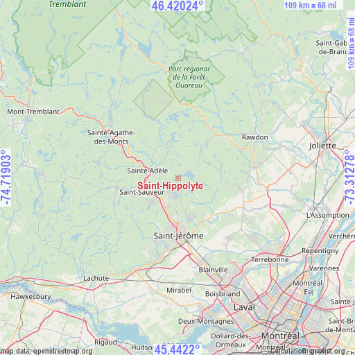
Saint-Hippolyte GPS coordinates[2]
45° 56' 0.168" North, 74° 0' 57.24" West
| Map corner | latitude | longitude |
|---|---|---|
| Upper-left | 46.42024°, | -74.71903° |
| Center: | 45.93338°, | -74.0159° |
| Lower-right: | 45.4422°, | -73.31278° |
| Map W x H: | 108.7×108.7 km | = 67.5×67.5mi |
| max Lat: | 73.03752° ⇑65% North |
| Saint-Hippolyte: | 45.93338° |
| min Lat: | ⇓35% South 42.05009° |
| min Long | Saint-Hippolyte | max Long |
| -139.43328° | -74.0159° | -52.70931° |
| W 62.1%⇐ | ⇒37.9% E |
Elevation
Elevation of Saint-Hippolyte is 254 m = 833 ft, and this is 0.40000000000001 m = 1 ft below average elevation for this country.
| Max E: |
1518 m = 4980 ft | 35.4% |
| Avg. | 254.4 m = 835 ft | |
| Saint-Hippolyte | 254 m = 833 ft | |
Min E: |
-2 m = -7 ft | 64.6% |
See also: Canada elevation on elevation.city.
Geographical zone
Saint-Hippolyte is located in North temperate zone (between Tropic of Cancer and the Arctic Circle). Distance of this North polar circle is 2293.9 km =1425.4 mi to North.| Distance of | km | miles | from Saint-Hippolyte |
|---|---|---|---|
| North Pole | 4899.7 | 3044.5 | to North |
| Arctic Circle | 2293.9 | 1425.4 | to North |
| Tropic Cancer | 2501.4 | 1554.3 | to South |
| Equator | 5107.3 | 3173.5 | to South |


Nearby cities:
15 places around Saint-Hippolyte: (largest is in red/bold)
• Chertsey
18.1 km =11.2 mi,  32°
32°
• Lac-Alouette
13.7 km =8.5 mi,  161°
161°
• Lac-Connelly
5.2 km =3.2 mi,  139°
139°
• Lac-Lapierre
19.2 km =11.9 mi,  101°
101°
• Morin-Heights
18.4 km =11.4 mi,  258°
258°
• Piedmont
9.8 km =6.1 mi,  247°
247°
• Prévost
9 km =5.6 mi,  214°
214°
• Saint-Jérôme
17 km =10.6 mi,  176°
176°
• Saint-Sauveur
13.7 km =8.5 mi, 247°
• Saint-Sauveur-des-Monts
12.2 km =7.6 mi, 252°
• Sainte-Adèle
9.2 km =5.7 mi,  281°
281°
• Sainte-Sophie
15.8 km =9.8 mi,  145°
145°
• Terrasse-des-Pins
8.6 km =5.3 mi, 206°
• Val-David
19 km =11.8 mi,  305°
305°
• Val-Morin
14.9 km =9.3 mi,  299°
299°
Sources, notices
• [Note1] Compared only with cities in Canada existing in our database
• [Src1] Map data: © OpenStreetMap contributors (CC-BY-SA)
• [Src2] Other city data from geonames.org with taken over terms of usage.
• [Src3] Geographical zone / Annual Mean Temperature by Robert A. Rohde @ Wikipedia
