Sainte-Sophie geodata
Sainte-Sophie (Quebec) is a populated place; located in Canada in America/Toronto (GMT-4) time zone. With population of 1,634 people, there are 830 cities with bigger population in this country. Compared to other cities in Canada, 67.7% of cities are located further ↑North; 63.7% of cities are located further ←West and 65.7% of cities have higher elevation than Sainte-Sophie. Note1


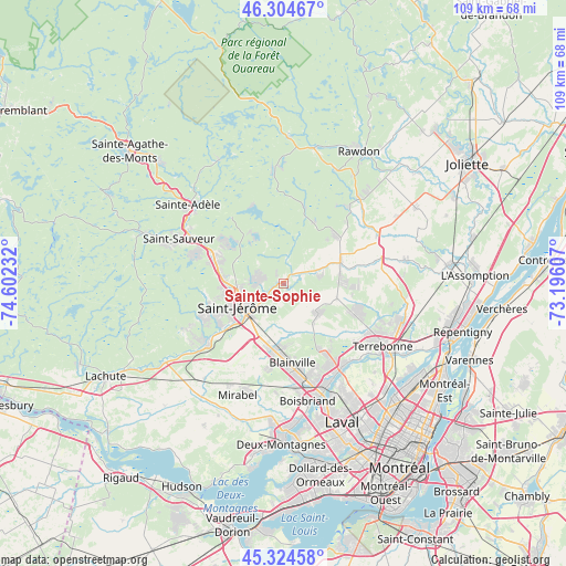
Sainte-Sophie GPS coordinates[2]
45° 49' 0.408" North, 73° 53' 57.084" West
| Map corner | latitude | longitude |
|---|---|---|
| Upper-left | 46.30467°, | -74.60232° |
| Center: | 45.81678°, | -73.89919° |
| Lower-right: | 45.32458°, | -73.19607° |
| Map W x H: | 109×109 km | = 67.7×67.7mi |
| max Lat: | 73.03752° ⇑67.7% North |
| Sainte-Sophie: | 45.81678° |
| min Lat: | ⇓32.3% South 42.05009° |
| min Long | Sainte-Sophie | max Long |
| -139.43328° | -73.89919° | -52.70931° |
| W 63.7%⇐ | ⇒36.3% E |
Elevation
Elevation of Sainte-Sophie is 73 m = 240 ft, and this is 181.4 m = 595 ft below average elevation for this country.
| Max E: |
1518 m = 4980 ft | 65.7% |
| Avg. | 254.4 m = 835 ft | |
| Sainte-Sophie | 73 m = 240 ft | |
Min E: |
-2 m = -7 ft | 34.3% |
See also: Canada elevation on elevation.city.
Geographical zone
Sainte-Sophie is located in North temperate zone (between Tropic of Cancer and the Arctic Circle). Distance of this North polar circle is 2306.8 km =1433.4 mi to North.| Distance of | km | miles | from Sainte-Sophie |
|---|---|---|---|
| North Pole | 4912.7 | 3052.6 | to North |
| Arctic Circle | 2306.8 | 1433.4 | to North |
| Tropic Cancer | 2488.4 | 1546.2 | to South |
| Equator | 5094.3 | 3165.5 | to South |


Nearby cities:
15 places around Sainte-Sophie: (largest is in red/bold)
• Blainville
16.7 km =10.4 mi,  175°
175°
• Bois-des-Filion
20.3 km =12.6 mi,  145°
145°
• Lac-Alouette
4.7 km =2.9 mi,  270°
270°
• Lac-Connelly
10.6 km =6.6 mi,  327°
327°
• Lac-Lapierre
13.3 km =8.3 mi,  47°
47°
• Lorraine
17.4 km =10.8 mi, 148°
• Piedmont
20.3 km =12.6 mi,  297°
297°
• Prévost
15.2 km =9.4 mi,  291°
291°
• Saint-Canut
18.2 km =11.3 mi,  231°
231°
• Saint-Colomban
20.3 km =12.6 mi,  242°
242°
• Saint-Hippolyte
15.8 km =9.8 mi, 325°
• Saint-Jérôme
9.1 km =5.7 mi, 243°
• Saint-Lin-Laurentides
11 km =6.8 mi,  70°
70°
• Sainte-Anne-des-Plaines
8.9 km =5.5 mi,  130°
130°
• Terrasse-des-Pins
14 km =8.7 mi, 292°
Sources, notices
• [Note1] Compared only with cities in Canada existing in our database
• [Src1] Map data: © OpenStreetMap contributors (CC-BY-SA)
• [Src2] Other city data from geonames.org with taken over terms of usage.
• [Src3] Geographical zone / Annual Mean Temperature by Robert A. Rohde @ Wikipedia
