Obo geodata
Obo (Haut-Mbomou) is a seat of a first-order administrative division; located in Central African Republic in Africa/Bangui (GMT+1) time zone. With population of 12,887 people, there are 24 cities with bigger population in this country. Compared to other cities in Central African Republic, 54.3% of cities are located further ↓South; 100% of cities are located further ←West and 88.6% of cities have lower elevation than Obo. Note1


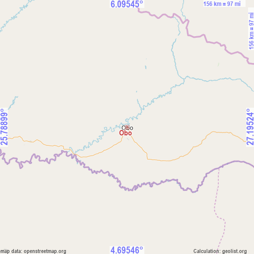
Obo GPS coordinates[2]
5° 23' 45.096" North, 26° 29' 31.596" East
| Map corner | latitude | longitude |
|---|---|---|
| Upper-left | 6.09545°, | 25.78899° |
| Center: | 5.39586°, | 26.49211° |
| Lower-right: | 4.69546°, | 27.19524° |
| Map W x H: | 155.7×155.7 km | = 96.7×96.7mi |
| max Lat: | 10.28488° ⇑45.7% North |
| Obo: | 5.39586° |
| min Lat: | ⇓54.3% South 3.52494° |
| min Long | Obo | max Long |
| 15.13926° | 26.49211° | 26.49211° |
| W 100%⇐ | ⇒0% E |
Elevation
Elevation of Obo is 639 m = 2096 ft, and this is 133.7 m = 439 ft above average elevation for this country.
| Max E: |
976 m = 3202 ft | 11.4% |
| Obo | 639 m 2096 ft | |
| Avg. | 505.3 m = 1658 ft | |
Min E: |
351 m = 1152 ft | 88.6% |
See also: Central African Republic elevation on elevation.city.
Geographical zone
Obo is located in North Torrid zone (between Equator and Tropic of Cancer). Distance of Equator is 600 km =372.8 mi to South.| Distance of | km | miles | from Obo |
|---|---|---|---|
| North Pole | 9407.1 | 5845.3 | to North |
| Arctic Circle | 6801.2 | 4226.1 | to North |
| Tropic Cancer | 2006 | 1246.5 | to North |
| Equator | 600 | 372.8 | to South |


Nearby cities:
2 places around Obo: (largest is in red/bold)
• Bangassou
413.3 km =256.8 mi,  259°
259°
• Zemio
155.5 km =96.6 mi,  254°
254°
Sources, notices
• [Note1] Compared only with cities in Central African Republic existing in our database
• [Src1] Map data: © OpenStreetMap contributors (CC-BY-SA)
• [Src2] Other city data from geonames.org with taken over terms of usage.
• [Src3] Geographical zone / Annual Mean Temperature by Robert A. Rohde @ Wikipedia
