Worben geodata
Worben (Bern) is a populated place; located in Switzerland in Europe/Zurich (GMT+2) time zone. With population of 2,042 people, there are 820 cities with bigger population in this country. Compared to other cities in Switzerland, 58.8% of cities are located further ↑North; 79.7% of cities are located further →East and 70.2% of cities have higher elevation than Worben. Note1


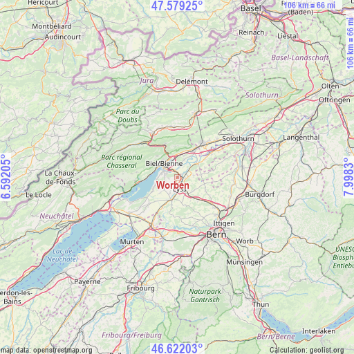
Worben GPS coordinates[2]
47° 6' 10.044" North, 7° 17' 42.648" East
| Map corner | latitude | longitude |
|---|---|---|
| Upper-left | 47.57925°, | 6.59205° |
| Center: | 47.10279°, | 7.29518° |
| Lower-right: | 46.62203°, | 7.9983° |
| Map W x H: | 106.4×106.4 km | = 66.1×66.1mi |
| max Lat: | 47.76737° ⇑58.8% North |
| Worben: | 47.10279° |
| min Lat: | ⇓41.2% South 45.83203° |
| min Long | Worben | max Long |
| 5.97153° | 7.29518° | 10.44624° |
| W 20.3%⇐ | ⇒79.7% E |
Elevation
Elevation of Worben is 439 m = 1440 ft, and this is 119.2 m = 391 ft below average elevation for this country.
| Max E: |
1845 m = 6053 ft | 70.2% |
| Avg. | 558.2 m = 1831 ft | |
| Worben | 439 m = 1440 ft | |
Min E: |
197 m = 646 ft | 29.8% |
See also: Switzerland elevation on elevation.city.
Geographical zone
Worben is located in North temperate zone (between Tropic of Cancer and the Arctic Circle). Distance of this North polar circle is 2163.8 km =1344.5 mi to North.| Distance of | km | miles | from Worben |
|---|---|---|---|
| North Pole | 4769.7 | 2963.8 | to North |
| Arctic Circle | 2163.8 | 1344.5 | to North |
| Tropic Cancer | 2631.4 | 1635.1 | to South |
| Equator | 5237.3 | 3254.3 | to South |


Nearby cities:
15 places around Worben: (largest is in red/bold)
• Aarberg
6.7 km =4.2 mi,  192°
192°
• Bellmund
3.8 km =2.4 mi,  279°
279°
• Biel/Bienne
5.3 km =3.3 mi,  315°
315°
• Brügg
2.6 km =1.6 mi,  332°
332°
• Büren an der Aare
7.1 km =4.4 mi,  54°
54°
• Evilard
6.8 km =4.2 mi, 321°
• Grossaffoltern
6.3 km =3.9 mi,  131°
131°
• Kappelen
5.2 km =3.2 mi,  203°
203°
• Lyss
3.3 km =2.1 mi,  164°
164°
• Magglingen
7.3 km =4.5 mi,  303°
303°
• Meinisberg
7.5 km =4.7 mi,  32°
32°
• Mörigen
6.4 km =4 mi,  252°
252°
• Nidau
4.9 km =3 mi, 301°
• Orpund
4.1 km =2.5 mi,  13°
13°
• Schnottwil
7.5 km =4.7 mi,  82°
82°
Sources, notices
• [Note1] Compared only with cities in Switzerland existing in our database
• [Src1] Map data: © OpenStreetMap contributors (CC-BY-SA)
• [Src2] Other city data from geonames.org with taken over terms of usage.
• [Src3] Geographical zone / Annual Mean Temperature by Robert A. Rohde @ Wikipedia
