Schnottwil geodata
Schnottwil (Solothurn) is a populated place; located in Switzerland in Europe/Zurich (GMT+2) time zone. With population of 958 people, there are 1364 cities with bigger population in this country. Compared to other cities in Switzerland, 58.6% of cities are located further ↑North; 78% of cities are located further →East and 59.9% of cities have lower elevation than Schnottwil. Note1


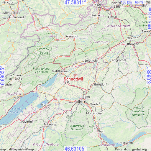
Schnottwil GPS coordinates[2]
47° 6' 42.228" North, 7° 23' 37.248" East
| Map corner | latitude | longitude |
|---|---|---|
| Upper-left | 47.58811°, | 6.69055° |
| Center: | 47.11173°, | 7.39368° |
| Lower-right: | 46.63105°, | 8.0968° |
| Map W x H: | 106.4×106.4 km | = 66.1×66.1mi |
| max Lat: | 47.76737° ⇑58.6% North |
| Schnottwil: | 47.11173° |
| min Lat: | ⇓41.4% South 45.83203° |
| min Long | Schnottwil | max Long |
| 5.97153° | 7.39368° | 10.44624° |
| W 22%⇐ | ⇒78% E |
Elevation
Elevation of Schnottwil is 518 m = 1699 ft, and this is 40.2 m = 132 ft below average elevation for this country.
| Max E: |
1845 m = 6053 ft | 40.1% |
| Avg. | 558.2 m = 1831 ft | |
| Schnottwil | 518 m = 1699 ft | |
Min E: |
197 m = 646 ft | 59.9% |
See also: Switzerland elevation on elevation.city.
Geographical zone
Schnottwil is located in North temperate zone (between Tropic of Cancer and the Arctic Circle). Distance of this North polar circle is 2162.8 km =1343.9 mi to North.| Distance of | km | miles | from Schnottwil |
|---|---|---|---|
| North Pole | 4768.7 | 2963.1 | to North |
| Arctic Circle | 2162.8 | 1343.9 | to North |
| Tropic Cancer | 2632.4 | 1635.7 | to South |
| Equator | 5238.3 | 3254.9 | to South |


Nearby cities:
15 places around Schnottwil: (largest is in red/bold)
• Arch
6.6 km =4.1 mi,  25°
25°
• Brügg
8.8 km =5.5 mi,  278°
278°
• Büren an der Aare
3.6 km =2.2 mi,  332°
332°
• Grenchen
8.9 km =5.5 mi,  1°
1°
• Grossaffoltern
5.9 km =3.7 mi,  208°
208°
• Lengnau
8 km =5 mi,  346°
346°
• Leuzigen
8.5 km =5.3 mi, 34°
• Lyss
7.8 km =4.8 mi,  237°
237°
• Meinisberg
6.4 km =4 mi, 327°
• Messen
4.5 km =2.8 mi,  119°
119°
• Orpund
7.2 km =4.5 mi,  294°
294°
• Pieterlen
8.2 km =5.1 mi, 329°
• Schüpfen
8.4 km =5.2 mi,  188°
188°
• Wengi
3.1 km =1.9 mi,  172°
172°
• Worben
7.5 km =4.7 mi,  262°
262°
Sources, notices
• [Note1] Compared only with cities in Switzerland existing in our database
• [Src1] Map data: © OpenStreetMap contributors (CC-BY-SA)
• [Src2] Other city data from geonames.org with taken over terms of usage.
• [Src3] Geographical zone / Annual Mean Temperature by Robert A. Rohde @ Wikipedia
