Sursee geodata
Sursee (Lucerne) is a seat of a second-order administrative division; located in Switzerland in Europe/Zurich (GMT+2) time zone. With population of 8,014 people, there are 195 cities with bigger population in this country. Compared to other cities in Switzerland, 55% of cities are located further ↑North; 57.6% of cities are located further →East and 56.4% of cities have lower elevation than Sursee. Note1


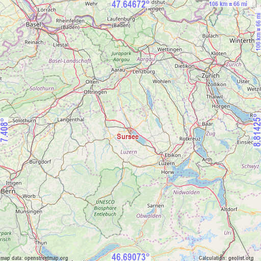
Sursee GPS coordinates[2]
47° 10' 15.168" North, 8° 6' 40.068" East
| Map corner | latitude | longitude |
|---|---|---|
| Upper-left | 47.64672°, | 7.408° |
| Center: | 47.17088°, | 8.11113° |
| Lower-right: | 46.69073°, | 8.81425° |
| Map W x H: | 106.3×106.3 km | = 66.1×66.1mi |
| max Lat: | 47.76737° ⇑55% North |
| Sursee: | 47.17088° |
| min Lat: | ⇓45% South 45.83203° |
| min Long | Sursee | max Long |
| 5.97153° | 8.11113° | 10.44624° |
| W 42.4%⇐ | ⇒57.6% E |
Elevation
Elevation of Sursee is 503 m = 1650 ft, and this is 55.2 m = 181 ft below average elevation for this country.
| Max E: |
1845 m = 6053 ft | 43.6% |
| Avg. | 558.2 m = 1831 ft | |
| Sursee | 503 m = 1650 ft | |
Min E: |
197 m = 646 ft | 56.4% |
See also: Switzerland elevation on elevation.city.
Geographical zone
Sursee is located in North temperate zone (between Tropic of Cancer and the Arctic Circle). Distance of this North polar circle is 2156.3 km =1339.9 mi to North.| Distance of | km | miles | from Sursee |
|---|---|---|---|
| North Pole | 4762.2 | 2959.1 | to North |
| Arctic Circle | 2156.3 | 1339.9 | to North |
| Tropic Cancer | 2639 | 1639.8 | to South |
| Equator | 5244.9 | 3259 | to South |


Nearby cities:
15 places around Sursee: (largest is in red/bold)
• Beromünster
7.3 km =4.5 mi,  57°
57°
• Buttisholz
6.4 km =4 mi,  191°
191°
• Büron
4.7 km =2.9 mi,  344°
344°
• Eich
4.8 km =3 mi,  117°
117°
• Geuensee
3.2 km =2 mi,  354°
354°
• Grosswangen
6.2 km =3.9 mi,  227°
227°
• Gunzwil
6.8 km =4.2 mi,  49°
49°
• Knutwil
4.3 km =2.7 mi,  317°
317°
• Mauensee
3.3 km =2.1 mi,  262°
262°
• Neudorf
7.4 km =4.6 mi,  84°
84°
• Nottwil
4.5 km =2.8 mi,  153°
153°
• Oberkirch
1.6 km =1 mi,  167°
167°
• Schenkon
1.8 km =1.1 mi, 64°
• Sempach
7.2 km =4.5 mi, 122°
• Wauwil
7 km =4.3 mi,  282°
282°
Sources, notices
• [Note1] Compared only with cities in Switzerland existing in our database
• [Src1] Map data: © OpenStreetMap contributors (CC-BY-SA)
• [Src2] Other city data from geonames.org with taken over terms of usage.
• [Src3] Geographical zone / Annual Mean Temperature by Robert A. Rohde @ Wikipedia
