Knutwil geodata
Knutwil (Lucerne) is a populated place; located in Switzerland in Europe/Zurich (GMT+2) time zone. With population of 1,722 people, there are 938 cities with bigger population in this country. Compared to other cities in Switzerland, 52.7% of cities are located further ↑North; 58.5% of cities are located further →East and 64.2% of cities have lower elevation than Knutwil. Note1


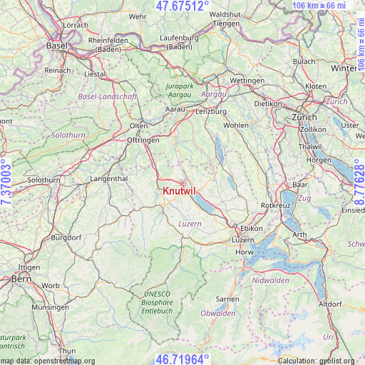
Knutwil GPS coordinates[2]
47° 11' 58.308" North, 8° 4' 23.34" East
| Map corner | latitude | longitude |
|---|---|---|
| Upper-left | 47.67512°, | 7.37003° |
| Center: | 47.19953°, | 8.07315° |
| Lower-right: | 46.71964°, | 8.77628° |
| Map W x H: | 106.2×106.2 km | = 66×66mi |
| max Lat: | 47.76737° ⇑52.7% North |
| Knutwil: | 47.19953° |
| min Lat: | ⇓47.3% South 45.83203° |
| min Long | Knutwil | max Long |
| 5.97153° | 8.07315° | 10.44624° |
| W 41.5%⇐ | ⇒58.5% E |
Elevation
Elevation of Knutwil is 542 m = 1778 ft, and this is 16.2 m = 53 ft below average elevation for this country.
| Max E: |
1845 m = 6053 ft | 35.8% |
| Avg. | 558.2 m = 1831 ft | |
| Knutwil | 542 m = 1778 ft | |
Min E: |
197 m = 646 ft | 64.2% |
See also: Switzerland elevation on elevation.city.
Geographical zone
Knutwil is located in North temperate zone (between Tropic of Cancer and the Arctic Circle). Distance of this North polar circle is 2153.1 km =1337.9 mi to North.| Distance of | km | miles | from Knutwil |
|---|---|---|---|
| North Pole | 4759 | 2957.1 | to North |
| Arctic Circle | 2153.1 | 1337.9 | to North |
| Tropic Cancer | 2642.2 | 1641.8 | to South |
| Equator | 5248.1 | 3261 | to South |


Nearby cities:
15 places around Knutwil: (largest is in red/bold)
• Büron
2.1 km =1.3 mi,  49°
49°
• Dagmersellen
6.8 km =4.2 mi,  283°
283°
• Ettiswil
6.9 km =4.3 mi,  217°
217°
• Geuensee
2.5 km =1.6 mi,  89°
89°
• Grosswangen
7.6 km =4.7 mi,  193°
193°
• Mauensee
3.6 km =2.2 mi, 186°
• Nebikon
7.3 km =4.5 mi,  263°
263°
• Oberkirch
5.8 km =3.6 mi,  146°
146°
• Schenkon
5.1 km =3.2 mi,  118°
118°
• Schötz
7.2 km =4.5 mi,  241°
241°
• Sursee
4.3 km =2.7 mi,  137°
137°
• Triengen
4 km =2.5 mi,  3°
3°
• Uffikon
4.3 km =2.7 mi,  286°
286°
• Wauwil
4.3 km =2.7 mi,  247°
247°
• Winikon
4.5 km =2.8 mi,  335°
335°
Sources, notices
• [Note1] Compared only with cities in Switzerland existing in our database
• [Src1] Map data: © OpenStreetMap contributors (CC-BY-SA)
• [Src2] Other city data from geonames.org with taken over terms of usage.
• [Src3] Geographical zone / Annual Mean Temperature by Robert A. Rohde @ Wikipedia
