Saint-Léonard geodata
Saint-Léonard (Valais) is a populated place; located in Switzerland in Europe/Zurich (GMT+2) time zone. With population of 1,937 people, there are 858 cities with bigger population in this country. Compared to other cities in Switzerland, 92.4% of cities are located further ↑North; 77.4% of cities are located further →East and 57.5% of cities have lower elevation than Saint-Léonard. Note1


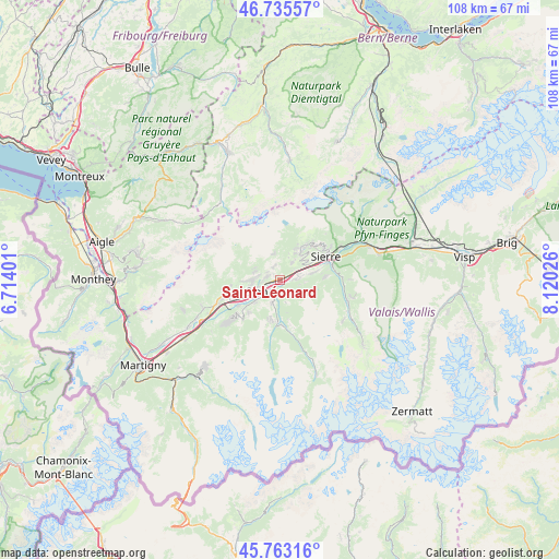
Saint-Léonard GPS coordinates[2]
46° 15' 5.472" North, 7° 25' 1.704" East
| Map corner | latitude | longitude |
|---|---|---|
| Upper-left | 46.73557°, | 6.71401° |
| Center: | 46.25152°, | 7.41714° |
| Lower-right: | 45.76316°, | 8.12026° |
| Map W x H: | 108.1×108.1 km | = 67.2×67.2mi |
| max Lat: | 47.76737° ⇑92.4% North |
| Saint-Léonard: | 46.25152° |
| min Lat: | ⇓7.6% South 45.83203° |
| min Long | Saint-Léonard | max Long |
| 5.97153° | 7.41714° | 10.44624° |
| W 22.6%⇐ | ⇒77.4% E |
Elevation
Elevation of Saint-Léonard is 506 m = 1660 ft, and this is 52.2 m = 171 ft below average elevation for this country.
| Max E: |
1845 m = 6053 ft | 42.5% |
| Avg. | 558.2 m = 1831 ft | |
| Saint-Léonard | 506 m = 1660 ft | |
Min E: |
197 m = 646 ft | 57.5% |
See also: Switzerland elevation on elevation.city.
Geographical zone
Saint-Léonard is located in North temperate zone (between Tropic of Cancer and the Arctic Circle). Distance of this North polar circle is 2258.5 km =1403.4 mi to North.| Distance of | km | miles | from Saint-Léonard |
|---|---|---|---|
| North Pole | 4864.4 | 3022.6 | to North |
| Arctic Circle | 2258.5 | 1403.4 | to North |
| Tropic Cancer | 2536.8 | 1576.3 | to South |
| Equator | 5142.7 | 3195.5 | to South |


Nearby cities:
15 places around Saint-Léonard: (largest is in red/bold)
• Arbaz
3.8 km =2.4 mi,  320°
320°
• Ayent
3.5 km =2.2 mi,  351°
351°
• Chalais
7.5 km =4.7 mi,  76°
76°
• Chermignon-d’en Haut
6 km =3.7 mi,  47°
47°
• Conthey
9.3 km =5.8 mi,  250°
250°
• Grimisuat
2.7 km =1.7 mi,  288°
288°
• Grône
3.3 km =2.1 mi,  87°
87°
• Hérémence
8 km =5 mi,  186°
186°
• Lens
4.3 km =2.7 mi,  35°
35°
• Montana
8.8 km =5.5 mi, 38°
• Randogne
9.1 km =5.7 mi, 44°
• Saint-Martin
9 km =5.6 mi,  166°
166°
• Savièse
5.5 km =3.4 mi,  269°
269°
• Sitten
5.4 km =3.4 mi,  240°
240°
• Vex
4.6 km =2.9 mi,  198°
198°
Sources, notices
• [Note1] Compared only with cities in Switzerland existing in our database
• [Src1] Map data: © OpenStreetMap contributors (CC-BY-SA)
• [Src2] Other city data from geonames.org with taken over terms of usage.
• [Src3] Geographical zone / Annual Mean Temperature by Robert A. Rohde @ Wikipedia
