Randogne geodata
Randogne (Valais) is a populated place; located in Switzerland in Europe/Zurich (GMT+2) time zone. With population of 3,157 people, there are 559 cities with bigger population in this country. Compared to other cities in Switzerland, 90.4% of cities are located further ↑North; 75.4% of cities are located further →East and 97.5% of cities have lower elevation than Randogne. Note1


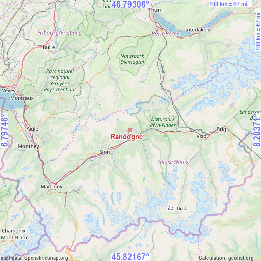
Randogne GPS coordinates[2]
46° 18' 34.272" North, 7° 30' 2.088" East
| Map corner | latitude | longitude |
|---|---|---|
| Upper-left | 46.79306°, | 6.79746° |
| Center: | 46.30952°, | 7.50058° |
| Lower-right: | 45.82167°, | 8.20371° |
| Map W x H: | 108×108 km | = 67.1×67.1mi |
| max Lat: | 47.76737° ⇑90.4% North |
| Randogne: | 46.30952° |
| min Lat: | ⇓9.6% South 45.83203° |
| min Long | Randogne | max Long |
| 5.97153° | 7.50058° | 10.44624° |
| W 24.6%⇐ | ⇒75.4% E |
Elevation
Elevation of Randogne is 1236 m = 4055 ft, and this is 677.8 m = 2224 ft above average elevation for this country.
| Max E: |
1845 m = 6053 ft | 2.5% |
| Randogne | 1236 m 4055 ft | |
| Avg. | 558.2 m = 1831 ft | |
Min E: |
197 m = 646 ft | 97.5% |
See also: Switzerland elevation on elevation.city.
Geographical zone
Randogne is located in North temperate zone (between Tropic of Cancer and the Arctic Circle). Distance of this North polar circle is 2252 km =1399.3 mi to North.| Distance of | km | miles | from Randogne |
|---|---|---|---|
| North Pole | 4857.9 | 3018.6 | to North |
| Arctic Circle | 2252 | 1399.3 | to North |
| Tropic Cancer | 2543.2 | 1580.3 | to South |
| Equator | 5149.1 | 3199.5 | to South |


Nearby cities:
15 places around Randogne: (largest is in red/bold)
• Arbaz
9.5 km =5.9 mi,  248°
248°
• Ayent
7.6 km =4.7 mi, 246°
• Chalais
4.7 km =2.9 mi,  169°
169°
• Chermignon-d’en Haut
3.1 km =1.9 mi,  220°
220°
• Chippis
4.4 km =2.7 mi,  137°
137°
• Grône
7 km =4.3 mi,  206°
206°
• Lens
4.9 km =3 mi,  232°
232°
• Leuk
10.3 km =6.4 mi,  85°
85°
• Miège
3.6 km =2.2 mi, 87°
• Montana
1 km =0.6 mi,  294°
294°
• Saint-Léonard
9.1 km =5.7 mi, 224°
• Salgesch
5.4 km =3.4 mi, 87°
• Sierre
3.3 km =2.1 mi,  126°
126°
• Varen
8.3 km =5.2 mi,  82°
82°
• Veyras
2.9 km =1.8 mi,  106°
106°
Sources, notices
• [Note1] Compared only with cities in Switzerland existing in our database
• [Src1] Map data: © OpenStreetMap contributors (CC-BY-SA)
• [Src2] Other city data from geonames.org with taken over terms of usage.
• [Src3] Geographical zone / Annual Mean Temperature by Robert A. Rohde @ Wikipedia
