Chermignon-d’en Haut geodata
Chermignon-d’en Haut (Valais) is a populated place; located in Switzerland in Europe/Zurich (GMT+2) time zone. With population of 2,773 people, there are 640 cities with bigger population in this country. Compared to other cities in Switzerland, 91.2% of cities are located further ↑North; 76.3% of cities are located further →East and 96.9% of cities have lower elevation than Chermignon-d’en Haut. Note1


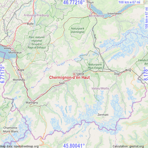
Chermignon-d’en Haut GPS coordinates[2]
46° 17' 18.384" North, 7° 28' 29.532" East
| Map corner | latitude | longitude |
|---|---|---|
| Upper-left | 46.77216°, | 6.77175° |
| Center: | 46.28844°, | 7.47487° |
| Lower-right: | 45.80041°, | 8.178° |
| Map W x H: | 108×108 km | = 67.1×67.1mi |
| max Lat: | 47.76737° ⇑91.2% North |
| Chermignon-d’en Haut: | 46.28844° |
| min Lat: | ⇓8.8% South 45.83203° |
| min Long | Chermignon-d’ | max Long |
| 5.97153° | 7.47487° | 10.44624° |
| W 23.7%⇐ | ⇒76.3% E |
Elevation
Elevation of Chermignon-d’en Haut is 1149 m = 3770 ft, and this is 590.8 m = 1938 ft above average elevation for this country.
| Max E: |
1845 m = 6053 ft | 3.1% |
| Chermignon-d’en Haut | 1149 m 3770 ft | |
| Avg. | 558.2 m = 1831 ft | |
Min E: |
197 m = 646 ft | 96.9% |
See also: Switzerland elevation on elevation.city.
Geographical zone
Chermignon-d’en Haut is located in North temperate zone (between Tropic of Cancer and the Arctic Circle). Distance of this North polar circle is 2254.4 km =1400.8 mi to North.| Distance of | km | miles | from Chermignon-d’en Haut |
|---|---|---|---|
| North Pole | 4860.3 | 3020 | to North |
| Arctic Circle | 2254.4 | 1400.8 | to North |
| Tropic Cancer | 2540.9 | 1578.8 | to South |
| Equator | 5146.8 | 3198.1 | to South |


Nearby cities:
15 places around Chermignon-d’en Haut: (largest is in red/bold)
• Arbaz
7 km =4.3 mi,  260°
260°
• Ayent
5 km =3.1 mi, 262°
• Chalais
3.6 km =2.2 mi,  129°
129°
• Chippis
5.1 km =3.2 mi,  100°
100°
• Grimisuat
7.7 km =4.8 mi,  245°
245°
• Grône
4.1 km =2.5 mi,  196°
196°
• Lens
2 km =1.2 mi, 252°
• Miège
6.1 km =3.8 mi,  65°
65°
• Montana
3 km =1.9 mi,  20°
20°
• Randogne
3.1 km =1.9 mi,  40°
40°
• Saint-Léonard
6 km =3.7 mi,  227°
227°
• Salgesch
7.8 km =4.8 mi, 70°
• Sierre
4.7 km =2.9 mi,  85°
85°
• Vex
10.3 km =6.4 mi,  214°
214°
• Veyras
5 km =3.1 mi, 72°
Sources, notices
• [Note1] Compared only with cities in Switzerland existing in our database
• [Src1] Map data: © OpenStreetMap contributors (CC-BY-SA)
• [Src2] Other city data from geonames.org with taken over terms of usage.
• [Src3] Geographical zone / Annual Mean Temperature by Robert A. Rohde @ Wikipedia
