Klosters Serneus geodata
Klosters Serneus (Grisons) is a populated place; located in Switzerland in Europe/Zurich (GMT+2) time zone. With population of 4,044 people, there are 433 cities with bigger population in this country. Compared to other cities in Switzerland, 70.2% of cities are located further ↑North; 99.3% of cities are located further ←West and 94.6% of cities have lower elevation than Klosters Serneus. Note1
Administrative division(s):
- Level 1: Grisons
- Level 2: Region Prättigau / Davos
- Level 3: Klosters-Serneus


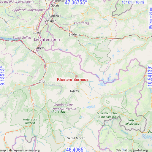
Klosters Serneus GPS coordinates[2]
46° 53' 21.048" North, 9° 50' 17.736" East
| Map corner | latitude | longitude |
|---|---|---|
| Upper-left | 47.36755°, | 9.13513° |
| Center: | 46.88918°, | 9.83826° |
| Lower-right: | 46.4065°, | 10.54139° |
| Map W x H: | 106.9×106.9 km | = 66.4×66.4mi |
| max Lat: | 47.76737° ⇑70.2% North |
| Klosters Serneus: | 46.88918° |
| min Lat: | ⇓29.8% South 45.83203° |
| min Long | Klosters Serneu | max Long |
| 5.97153° | 9.83826° | 10.44624° |
| W 99.3%⇐ | ⇒0.7% E |
Elevation
Elevation of Klosters Serneus is 998 m = 3274 ft, and this is 439.8 m = 1443 ft above average elevation for this country.
| Max E: |
1845 m = 6053 ft | 5.4% |
| Klosters Serneus | 998 m 3274 ft | |
| Avg. | 558.2 m = 1831 ft | |
Min E: |
197 m = 646 ft | 94.6% |
See also: Switzerland elevation on elevation.city.
Geographical zone
Klosters Serneus is located in North temperate zone (between Tropic of Cancer and the Arctic Circle). Distance of this North polar circle is 2187.6 km =1359.3 mi to North.| Distance of | km | miles | from Klosters Serneus |
|---|---|---|---|
| North Pole | 4793.5 | 2978.5 | to North |
| Arctic Circle | 2187.6 | 1359.3 | to North |
| Tropic Cancer | 2607.7 | 1620.3 | to South |
| Equator | 5213.6 | 3239.6 | to South |


Nearby cities:
15 places around Klosters Serneus: (largest is in red/bold)
• Arosa
17.5 km =10.9 mi,  224°
224°
• Davos
9.4 km =5.8 mi,  180°
180°
• Fideris
7.9 km =4.9 mi,  292°
292°
• Grüsch
17.7 km =11 mi,  304°
304°
• Igis
21.2 km =13.2 mi, 287°
• Jenaz
10.5 km =6.5 mi, 294°
• Küblis
5.3 km =3.3 mi, 302°
• Landquart
21.7 km =13.5 mi, 288°
• Luzein
6.8 km =4.2 mi, 299°
• Malans
22.4 km =13.9 mi, 297°
• Saas im Prättigau
3.2 km =2 mi,  316°
316°
• Schiers
14.6 km =9.1 mi,  307°
307°
• Trimmis
21.1 km =13.1 mi,  273°
273°
• Untervaz
23.5 km =14.6 mi,  280°
280°
• Zizers
21.4 km =13.3 mi, 284°
Sources, notices
• [Note1] Compared only with cities in Switzerland existing in our database
• [Src1] Map data: © OpenStreetMap contributors (CC-BY-SA)
• [Src2] Other city data from geonames.org with taken over terms of usage.
• [Src3] Geographical zone / Annual Mean Temperature by Robert A. Rohde @ Wikipedia
