Fideris geodata
Fideris (Grisons) is a populated place; located in Switzerland in Europe/Zurich (GMT+2) time zone. With population of 579 people, there are 1715 cities with bigger population in this country. Compared to other cities in Switzerland, 68.6% of cities are located further ↑North; 98.8% of cities are located further ←West and 91.9% of cities have lower elevation than Fideris. Note1


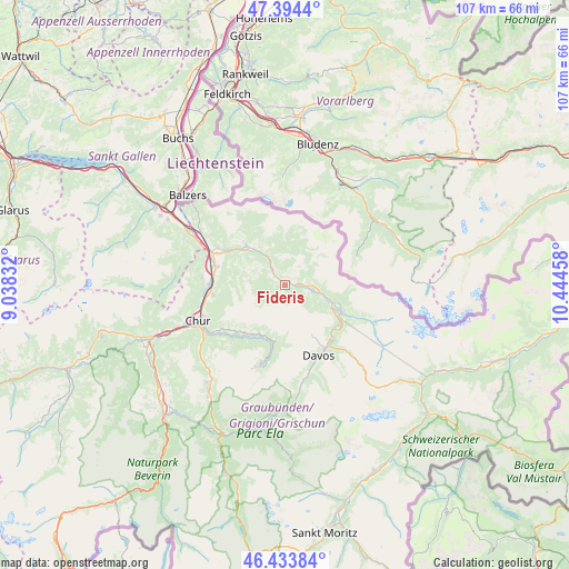
Fideris GPS coordinates[2]
46° 54' 58.572" North, 9° 44' 29.22" East
| Map corner | latitude | longitude |
|---|---|---|
| Upper-left | 47.3944°, | 9.03832° |
| Center: | 46.91627°, | 9.74145° |
| Lower-right: | 46.43384°, | 10.44458° |
| Map W x H: | 106.8×106.8 km | = 66.4×66.4mi |
| max Lat: | 47.76737° ⇑68.6% North |
| Fideris: | 46.91627° |
| min Lat: | ⇓31.4% South 45.83203° |
| min Long | Fideris | max Long |
| 5.97153° | 9.74145° | 10.44624° |
| W 98.8%⇐ | ⇒1.2% E |
Elevation
Elevation of Fideris is 876 m = 2874 ft, and this is 317.8 m = 1043 ft above average elevation for this country.
| Max E: |
1845 m = 6053 ft | 8.1% |
| Fideris | 876 m 2874 ft | |
| Avg. | 558.2 m = 1831 ft | |
Min E: |
197 m = 646 ft | 91.9% |
See also: Switzerland elevation on elevation.city.
Geographical zone
Fideris is located in North temperate zone (between Tropic of Cancer and the Arctic Circle). Distance of this North polar circle is 2184.6 km =1357.4 mi to North.| Distance of | km | miles | from Fideris |
|---|---|---|---|
| North Pole | 4790.5 | 2976.7 | to North |
| Arctic Circle | 2184.6 | 1357.4 | to North |
| Tropic Cancer | 2610.7 | 1622.2 | to South |
| Equator | 5216.6 | 3241.4 | to South |


Nearby cities:
15 places around Fideris: (largest is in red/bold)
• Davos
14.4 km =8.9 mi,  149°
149°
• Grüsch
10.1 km =6.3 mi,  314°
314°
• Igis
13.3 km =8.3 mi,  284°
284°
• Jenaz
2.6 km =1.6 mi,  302°
302°
• Klosters Serneus
7.9 km =4.9 mi,  112°
112°
• Küblis
2.9 km =1.8 mi,  94°
94°
• Landquart
13.8 km =8.6 mi,  285°
285°
• Luzein
1.5 km =0.9 mi,  75°
75°
• Malans
14.5 km =9 mi, 299°
• Mastrils
16.1 km =10 mi, 291°
• Saas im Prättigau
5.1 km =3.2 mi,  97°
97°
• Schiers
7.2 km =4.5 mi,  325°
325°
• Trimmis
13.8 km =8.6 mi,  262°
262°
• Untervaz
15.8 km =9.8 mi,  274°
274°
• Zizers
13.6 km =8.5 mi, 279°
Sources, notices
• [Note1] Compared only with cities in Switzerland existing in our database
• [Src1] Map data: © OpenStreetMap contributors (CC-BY-SA)
• [Src2] Other city data from geonames.org with taken over terms of usage.
• [Src3] Geographical zone / Annual Mean Temperature by Robert A. Rohde @ Wikipedia
