Caslano geodata
Caslano (Ticino) is a populated place; located in Switzerland in Europe/Zurich (GMT+2) time zone. With population of 3,655 people, there are 488 cities with bigger population in this country. Compared to other cities in Switzerland, 99% of cities are located further ↑North; 84.4% of cities are located further ←West and 98.1% of cities have higher elevation than Caslano. Note1


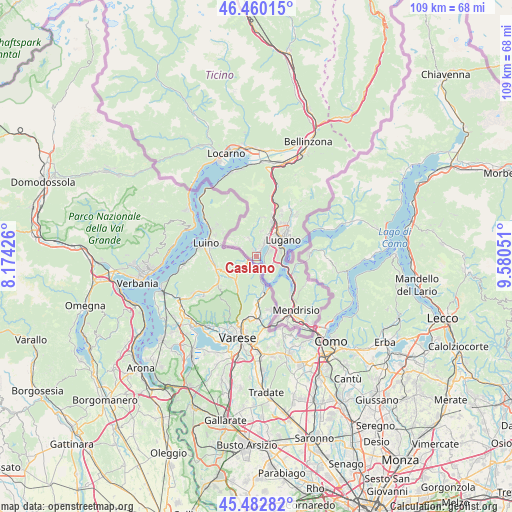
Caslano GPS coordinates[2]
45° 58' 25.104" North, 8° 52' 38.604" East
| Map corner | latitude | longitude |
|---|---|---|
| Upper-left | 46.46015°, | 8.17426° |
| Center: | 45.97364°, | 8.87739° |
| Lower-right: | 45.48282°, | 9.58051° |
| Map W x H: | 108.7×108.7 km | = 67.5×67.5mi |
| max Lat: | 47.76737° ⇑99% North |
| Caslano: | 45.97364° |
| min Lat: | ⇓1% South 45.83203° |
| min Long | Caslano | max Long |
| 5.97153° | 8.87739° | 10.44624° |
| W 84.4%⇐ | ⇒15.6% E |
Elevation
Elevation of Caslano is 282 m = 925 ft, and this is 276.2 m = 906 ft below average elevation for this country.
| Max E: |
1845 m = 6053 ft | 98.1% |
| Avg. | 558.2 m = 1831 ft | |
| Caslano | 282 m = 925 ft | |
Min E: |
197 m = 646 ft | 1.9% |
See also: Switzerland elevation on elevation.city.
Geographical zone
Caslano is located in North temperate zone (between Tropic of Cancer and the Arctic Circle). Distance of this North polar circle is 2289.4 km =1422.6 mi to North.| Distance of | km | miles | from Caslano |
|---|---|---|---|
| North Pole | 4895.3 | 3041.8 | to North |
| Arctic Circle | 2289.4 | 1422.6 | to North |
| Tropic Cancer | 2505.9 | 1557.1 | to South |
| Equator | 5111.8 | 3176.3 | to South |


Nearby cities:
15 places around Caslano: (largest is in red/bold)
• Agno
3.3 km =2.1 mi,  32°
32°
• Bedigliora
4.3 km =2.7 mi,  318°
318°
• Bioggio
5.1 km =3.2 mi, 30°
• Cadempino
8.3 km =5.2 mi, 31°
• Gravesano
8.2 km =5.1 mi,  22°
22°
• Lugano
7.6 km =4.7 mi,  57°
57°
• Massagno
6.7 km =4.2 mi,  49°
49°
• Melide
5.8 km =3.6 mi,  111°
111°
• Montagnola
3.3 km =2.1 mi,  71°
71°
• Morcote
6.2 km =3.9 mi,  151°
151°
• Novaggio
4.4 km =2.7 mi,  337°
337°
• Pura
1.6 km =1 mi,  334°
334°
• Savosa
7.1 km =4.4 mi,  44°
44°
• Sessa
5.2 km =3.2 mi,  301°
301°
• Sorengo
5.4 km =3.4 mi, 60°
Sources, notices
• [Note1] Compared only with cities in Switzerland existing in our database
• [Src1] Map data: © OpenStreetMap contributors (CC-BY-SA)
• [Src2] Other city data from geonames.org with taken over terms of usage.
• [Src3] Geographical zone / Annual Mean Temperature by Robert A. Rohde @ Wikipedia
