Cadempino geodata
Cadempino (Ticino) is a populated place; located in Switzerland in Europe/Zurich (GMT+2) time zone. With population of 1,351 people, there are 1106 cities with bigger population in this country. Compared to other cities in Switzerland, 98% of cities are located further ↑North; 85.6% of cities are located further ←West and 96.8% of cities have higher elevation than Cadempino. Note1


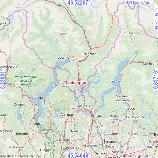
Cadempino GPS coordinates[2]
46° 2' 12.192" North, 8° 56' 2.508" East
| Map corner | latitude | longitude |
|---|---|---|
| Upper-left | 46.52267°, | 8.23091° |
| Center: | 46.03672°, | 8.93403° |
| Lower-right: | 45.54646°, | 9.63716° |
| Map W x H: | 108.5×108.5 km | = 67.4×67.4mi |
| max Lat: | 47.76737° ⇑98% North |
| Cadempino: | 46.03672° |
| min Lat: | ⇓2% South 45.83203° |
| min Long | Cadempino | max Long |
| 5.97153° | 8.93403° | 10.44624° |
| W 85.6%⇐ | ⇒14.4% E |
Elevation
Elevation of Cadempino is 319 m = 1047 ft, and this is 239.2 m = 785 ft below average elevation for this country.
| Max E: |
1845 m = 6053 ft | 96.8% |
| Avg. | 558.2 m = 1831 ft | |
| Cadempino | 319 m = 1047 ft | |
Min E: |
197 m = 646 ft | 3.2% |
See also: Switzerland elevation on elevation.city.
Geographical zone
Cadempino is located in North temperate zone (between Tropic of Cancer and the Arctic Circle). Distance of this North polar circle is 2282.4 km =1418.2 mi to North.| Distance of | km | miles | from Cadempino |
|---|---|---|---|
| North Pole | 4888.3 | 3037.4 | to North |
| Arctic Circle | 2282.4 | 1418.2 | to North |
| Tropic Cancer | 2512.9 | 1561.4 | to South |
| Equator | 5118.8 | 3180.7 | to South |


Nearby cities:
15 places around Cadempino: (largest is in red/bold)
• Agno
5 km =3.1 mi,  211°
211°
• Bioggio
3.1 km =1.9 mi, 214°
• Cadro
4.2 km =2.6 mi,  75°
75°
• Cagiallo
4.6 km =2.9 mi,  41°
41°
• Canobbio
2.5 km =1.6 mi,  92°
92°
• Comano
1.6 km =1 mi, 91°
• Gravesano
1.4 km =0.9 mi,  296°
296°
• Lugano
3.6 km =2.2 mi,  145°
145°
• Massagno
2.8 km =1.7 mi,  164°
164°
• Montagnola
6.1 km =3.8 mi,  191°
191°
• Pregassona
3.6 km =2.2 mi,  120°
120°
• Savosa
2.1 km =1.3 mi, 161°
• Sorengo
4.4 km =2.7 mi,  176°
176°
• Tesserete
4.2 km =2.6 mi,  34°
34°
• Viganello
3.7 km =2.3 mi,  133°
133°
Sources, notices
• [Note1] Compared only with cities in Switzerland existing in our database
• [Src1] Map data: © OpenStreetMap contributors (CC-BY-SA)
• [Src2] Other city data from geonames.org with taken over terms of usage.
• [Src3] Geographical zone / Annual Mean Temperature by Robert A. Rohde @ Wikipedia
