Savosa geodata
Savosa (Ticino) is a seat of a third-order administrative division; located in Switzerland in Europe/Zurich (GMT+2) time zone. In our database, there are 1823 cities with bigger population. Compared to other cities in Switzerland, 98.4% of cities are located further ↑North; 85.8% of cities are located further ←West and 91.7% of cities have higher elevation than Savosa. Note1


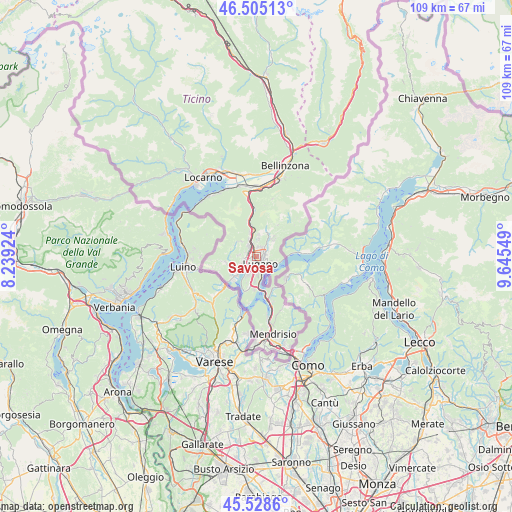
Savosa GPS coordinates[2]
46° 1' 8.472" North, 8° 56' 32.496" East
| Map corner | latitude | longitude |
|---|---|---|
| Upper-left | 46.50513°, | 8.23924° |
| Center: | 46.01902°, | 8.94236° |
| Lower-right: | 45.5286°, | 9.64549° |
| Map W x H: | 108.6×108.6 km | = 67.5×67.5mi |
| max Lat: | 47.76737° ⇑98.4% North |
| Savosa: | 46.01902° |
| min Lat: | ⇓1.6% South 45.83203° |
| min Long | Savosa | max Long |
| 5.97153° | 8.94236° | 10.44624° |
| W 85.8%⇐ | ⇒14.2% E |
Elevation
Elevation of Savosa is 387 m = 1270 ft, and this is 171.2 m = 562 ft below average elevation for this country.
| Max E: |
1845 m = 6053 ft | 91.7% |
| Avg. | 558.2 m = 1831 ft | |
| Savosa | 387 m = 1270 ft | |
Min E: |
197 m = 646 ft | 8.3% |
See also: Switzerland elevation on elevation.city.
Geographical zone
Savosa is located in North temperate zone (between Tropic of Cancer and the Arctic Circle). Distance of this North polar circle is 2284.3 km =1419.4 mi to North.| Distance of | km | miles | from Savosa |
|---|---|---|---|
| North Pole | 4890.2 | 3038.6 | to North |
| Arctic Circle | 2284.3 | 1419.4 | to North |
| Tropic Cancer | 2510.9 | 1560.2 | to South |
| Equator | 5116.8 | 3179.4 | to South |


Nearby cities:
15 places around Savosa: (largest is in red/bold)
• Agno
4 km =2.5 mi,  235°
235°
• Bioggio
2.5 km =1.6 mi,  255°
255°
• Cadempino
2.1 km =1.3 mi,  341°
341°
• Cadro
4.6 km =2.9 mi,  49°
49°
• Cagiallo
5.9 km =3.7 mi,  23°
23°
• Canobbio
2.6 km =1.6 mi,  44°
44°
• Comano
2.2 km =1.4 mi,  27°
27°
• Gravesano
3.2 km =2 mi,  324°
324°
• Lugano
1.7 km =1.1 mi,  126°
126°
• Massagno
0.7 km =0.4 mi,  172°
172°
• Montagnola
4.4 km =2.7 mi,  205°
205°
• Pregassona
2.5 km =1.6 mi,  86°
86°
• Sorengo
2.4 km =1.5 mi,  188°
188°
• Tesserete
5.7 km =3.5 mi, 17°
• Viganello
2.1 km =1.3 mi,  106°
106°
Sources, notices
• [Note1] Compared only with cities in Switzerland existing in our database
• [Src1] Map data: © OpenStreetMap contributors (CC-BY-SA)
• [Src2] Other city data from geonames.org with taken over terms of usage.
• [Src3] Geographical zone / Annual Mean Temperature by Robert A. Rohde @ Wikipedia
