Kloten / Hostrass geodata
Kloten / Hostrass (Zurich) is a section of populated place; located in Switzerland in Europe/Zurich (GMT+2) time zone. With population of 1,012 people, there are 1317 cities with bigger population in this country. Compared to other cities in Switzerland, 82.8% of cities are located further ↓South; 65.9% of cities are located further ←West and 64.5% of cities have higher elevation than Kloten / Hostrass. Note1


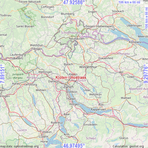
Kloten / Hostrass GPS coordinates[2]
47° 27' 9.18" North, 8° 35' 40.704" East
| Map corner | latitude | longitude |
|---|---|---|
| Upper-left | 47.92586°, | 7.89151° |
| Center: | 47.45255°, | 8.59464° |
| Lower-right: | 46.97495°, | 9.29776° |
| Map W x H: | 105.7×105.7 km | = 65.7×65.7mi |
| max Lat: | 47.76737° ⇑17.2% North |
| Kloten / Hostrass: | 47.45255° |
| min Lat: | ⇓82.8% South 45.83203° |
| min Long | Kloten / Hostra | max Long |
| 5.97153° | 8.59464° | 10.44624° |
| W 65.9%⇐ | ⇒34.1% E |
Elevation
Elevation of Kloten / Hostrass is 447 m = 1467 ft, and this is 111.2 m = 365 ft below average elevation for this country.
| Max E: |
1845 m = 6053 ft | 64.5% |
| Avg. | 558.2 m = 1831 ft | |
| Kloten / Hostrass | 447 m = 1467 ft | |
Min E: |
197 m = 646 ft | 35.5% |
See also: Switzerland elevation on elevation.city.
Geographical zone
Kloten / Hostrass is located in North temperate zone (between Tropic of Cancer and the Arctic Circle). Distance of this North polar circle is 2124.9 km =1320.4 mi to North.| Distance of | km | miles | from Kloten / Hostrass |
|---|---|---|---|
| North Pole | 4730.8 | 2939.6 | to North |
| Arctic Circle | 2124.9 | 1320.4 | to North |
| Tropic Cancer | 2670.3 | 1659.2 | to South |
| Equator | 5276.2 | 3278.5 | to South |


Nearby cities:
15 places around Kloten / Hostrass: (largest is in red/bold)
• Bassersdorf
2.7 km =1.7 mi,  111°
111°
• Birchwil
3 km =1.9 mi,  86°
86°
• Glattbrugg / Rohr/Platten-Balsberg
2.7 km =1.7 mi,  231°
231°
• Glattbrugg / Zentrum Müllacker
2.8 km =1.7 mi,  223°
223°
• Kloten
0.7 km =0.4 mi,  261°
261°
• Kloten / Balsberg
1.9 km =1.2 mi, 232°
• Kloten / Bramen
1.5 km =0.9 mi, 228°
• Kloten / Freienberg (Chanzler-Chlini Chaseren)
1.8 km =1.1 mi,  326°
326°
• Kloten / Geissberg
0.4 km =0.2 mi,  302°
302°
• Kloten / Holberg
1.5 km =0.9 mi,  243°
243°
• Kloten / Horainli
0.9 km =0.6 mi,  280°
280°
• Kloten / Kloten (Zentrum)
0.6 km =0.4 mi, 257°
• Kloten / Rütlen
0.8 km =0.5 mi, 219°
• Kloten / Spitz
1 km =0.6 mi,  212°
212°
• Opfikon
2.7 km =1.7 mi, 211°
Sources, notices
• [Note1] Compared only with cities in Switzerland existing in our database
• [Src1] Map data: © OpenStreetMap contributors (CC-BY-SA)
• [Src2] Other city data from geonames.org with taken over terms of usage.
• [Src3] Geographical zone / Annual Mean Temperature by Robert A. Rohde @ Wikipedia
