Kloten / Balsberg geodata
Kloten / Balsberg (Zurich) is a section of populated place; located in Switzerland in Europe/Zurich (GMT+2) time zone. With population of 1,389 people, there are 1090 cities with bigger population in this country. Compared to other cities in Switzerland, 81.1% of cities are located further ↓South; 63.5% of cities are located further ←West and 57% of cities have higher elevation than Kloten / Balsberg. Note1


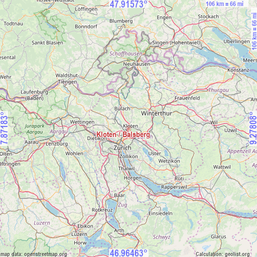
Kloten / Balsberg GPS coordinates[2]
47° 26' 32.388" North, 8° 34' 29.856" East
| Map corner | latitude | longitude |
|---|---|---|
| Upper-left | 47.91573°, | 7.87183° |
| Center: | 47.44233°, | 8.57496° |
| Lower-right: | 46.96463°, | 9.27808° |
| Map W x H: | 105.8×105.8 km | = 65.7×65.7mi |
| max Lat: | 47.76737° ⇑18.9% North |
| Kloten / Balsberg: | 47.44233° |
| min Lat: | ⇓81.1% South 45.83203° |
| min Long | Kloten / Balsbe | max Long |
| 5.97153° | 8.57496° | 10.44624° |
| W 63.5%⇐ | ⇒36.5% E |
Elevation
Elevation of Kloten / Balsberg is 462 m = 1516 ft, and this is 96.2 m = 316 ft below average elevation for this country.
| Max E: |
1845 m = 6053 ft | 57% |
| Avg. | 558.2 m = 1831 ft | |
| Kloten / Balsberg | 462 m = 1516 ft | |
Min E: |
197 m = 646 ft | 43% |
See also: Switzerland elevation on elevation.city.
Geographical zone
Kloten / Balsberg is located in North temperate zone (between Tropic of Cancer and the Arctic Circle). Distance of this North polar circle is 2126.1 km =1321.1 mi to North.| Distance of | km | miles | from Kloten / Balsberg |
|---|---|---|---|
| North Pole | 4732 | 2940.3 | to North |
| Arctic Circle | 2126.1 | 1321.1 | to North |
| Tropic Cancer | 2669.2 | 1658.6 | to South |
| Equator | 5275.1 | 3277.8 | to South |


Nearby cities:
15 places around Kloten / Balsberg: (largest is in red/bold)
• Glattbrugg
1.5 km =0.9 mi,  216°
216°
• Glattbrugg / Rohr/Platten-Balsberg
0.9 km =0.6 mi,  228°
228°
• Glattbrugg / Wydacker/Bettacker/Lättenwiesen
1.6 km =1 mi,  203°
203°
• Glattbrugg / Zentrum Müllacker
1 km =0.6 mi,  206°
206°
• Grossacker/Opfikon
1.7 km =1.1 mi,  170°
170°
• Kloten
1.3 km =0.8 mi,  36°
36°
• Kloten / Bramen
0.3 km =0.2 mi,  71°
71°
• Kloten / Geissberg
1.8 km =1.1 mi, 41°
• Kloten / Holberg
0.5 km =0.3 mi,  15°
15°
• Kloten / Horainli
1.4 km =0.9 mi,  25°
25°
• Kloten / Hostrass
1.9 km =1.2 mi,  52°
52°
• Kloten / Kloten (Zentrum)
1.3 km =0.8 mi, 41°
• Kloten / Rütlen
1.1 km =0.7 mi,  60°
60°
• Kloten / Spitz
1 km =0.6 mi,  75°
75°
• Opfikon
1.2 km =0.7 mi,  176°
176°
Sources, notices
• [Note1] Compared only with cities in Switzerland existing in our database
• [Src1] Map data: © OpenStreetMap contributors (CC-BY-SA)
• [Src2] Other city data from geonames.org with taken over terms of usage.
• [Src3] Geographical zone / Annual Mean Temperature by Robert A. Rohde @ Wikipedia
