Neerach geodata
Neerach (Zurich) is a populated place; located in Switzerland in Europe/Zurich (GMT+2) time zone. With population of 1,435 people, there are 1064 cities with bigger population in this country. Compared to other cities in Switzerland, 90.8% of cities are located further ↓South; 55.2% of cities are located further ←West and 63.8% of cities have higher elevation than Neerach. Note1


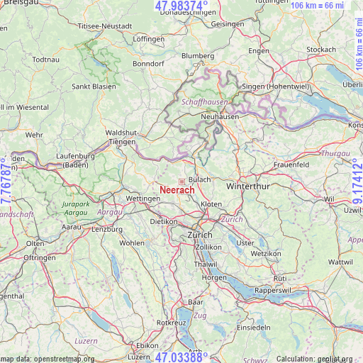
Neerach GPS coordinates[2]
47° 30' 39.456" North, 8° 28' 15.564" East
| Map corner | latitude | longitude |
|---|---|---|
| Upper-left | 47.98374°, | 7.76787° |
| Center: | 47.51096°, | 8.47099° |
| Lower-right: | 47.03388°, | 9.17412° |
| Map W x H: | 105.6×105.6 km | = 65.6×65.6mi |
| max Lat: | 47.76737° ⇑9.2% North |
| Neerach: | 47.51096° |
| min Lat: | ⇓90.8% South 45.83203° |
| min Long | Neerach | max Long |
| 5.97153° | 8.47099° | 10.44624° |
| W 55.2%⇐ | ⇒44.8% E |
Elevation
Elevation of Neerach is 448 m = 1470 ft, and this is 110.2 m = 362 ft below average elevation for this country.
| Max E: |
1845 m = 6053 ft | 63.8% |
| Avg. | 558.2 m = 1831 ft | |
| Neerach | 448 m = 1470 ft | |
Min E: |
197 m = 646 ft | 36.2% |
See also: Switzerland elevation on elevation.city.
Geographical zone
Neerach is located in North temperate zone (between Tropic of Cancer and the Arctic Circle). Distance of this North polar circle is 2118.5 km =1316.4 mi to North.| Distance of | km | miles | from Neerach |
|---|---|---|---|
| North Pole | 4724.3 | 2935.5 | to North |
| Arctic Circle | 2118.5 | 1316.4 | to North |
| Tropic Cancer | 2676.8 | 1663.3 | to South |
| Equator | 5282.7 | 3282.5 | to South |


Nearby cities:
15 places around Neerach: (largest is in red/bold)
• Bückler-Dörnler
3.4 km =2.1 mi,  95°
95°
• Dielsdorf
3.4 km =2.1 mi,  195°
195°
• Hochfelden
3.6 km =2.2 mi,  68°
68°
• Höri
3.1 km =1.9 mi, 96°
• Niederglatt
3.1 km =1.9 mi,  136°
136°
• Niederglatt / Grafschaft
3 km =1.9 mi,  127°
127°
• Niederglatt / Niederglatt (Dorfkern)
3.2 km =2 mi, 135°
• Niederglatt / Nöschikon
2.5 km =1.6 mi, 134°
• Niederhasli
3.6 km =2.2 mi,  162°
162°
• Ober-Höri
2.1 km =1.3 mi,  111°
111°
• Riedt
1.1 km =0.7 mi,  180°
180°
• Schibler
3 km =1.9 mi,  210°
210°
• Stadel
2.1 km =1.3 mi,  344°
344°
• Steinmaur
2.1 km =1.3 mi,  222°
222°
• Steinmaur / Nieder-Steinmaur
2.6 km =1.6 mi, 219°
Sources, notices
• [Note1] Compared only with cities in Switzerland existing in our database
• [Src1] Map data: © OpenStreetMap contributors (CC-BY-SA)
• [Src2] Other city data from geonames.org with taken over terms of usage.
• [Src3] Geographical zone / Annual Mean Temperature by Robert A. Rohde @ Wikipedia
