Schibler geodata
Schibler (Zurich) is a populated place; located in Switzerland in Europe/Zurich (GMT+2) time zone. With population of 835 people, there are 1470 cities with bigger population in this country. Compared to other cities in Switzerland, 87.1% of cities are located further ↓South; 53.2% of cities are located further ←West and 58.7% of cities have higher elevation than Schibler. Note1


Schibler GPS coordinates[2]
47° 29' 15.9" North, 8° 27' 2.232" East
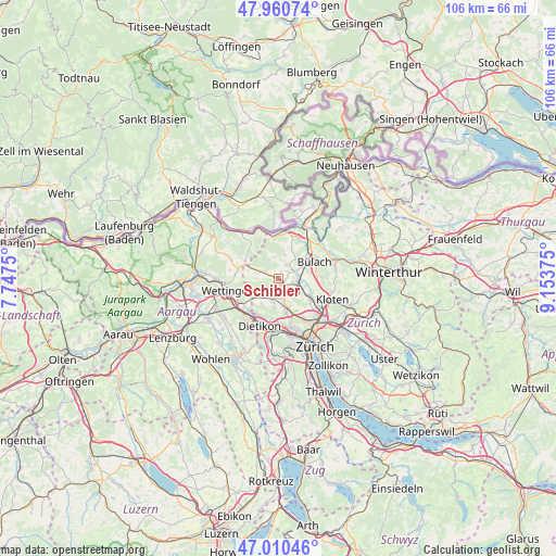
| Map corner | latitude | longitude |
|---|---|---|
| Upper-left | 47.96074°, | 7.7475° |
| Center: | 47.48775°, | 8.45062° |
| Lower-right: | 47.01046°, | 9.15375° |
| Map W x H: | 105.7×105.7 km | = 65.7×65.7mi |
| max Lat: | 47.76737° ⇑12.9% North |
| Schibler: | 47.48775° |
| min Lat: | ⇓87.1% South 45.83203° |
| min Long | Schibler | max Long |
| 5.97153° | 8.45062° | 10.44624° |
| W 53.2%⇐ | ⇒46.8% E |
Elevation
Elevation of Schibler is 457 m = 1499 ft, and this is 101.2 m = 332 ft below average elevation for this country.
| Max E: |
1845 m = 6053 ft | 58.7% |
| Avg. | 558.2 m = 1831 ft | |
| Schibler | 457 m = 1499 ft | |
Min E: |
197 m = 646 ft | 41.3% |
See also: Switzerland elevation on elevation.city.
Geographical zone
Schibler is located in North temperate zone (between Tropic of Cancer and the Arctic Circle). Distance of this North polar circle is 2121 km =1317.9 mi to North.| Distance of | km | miles | from Schibler |
|---|---|---|---|
| North Pole | 4726.9 | 2937.2 | to North |
| Arctic Circle | 2121 | 1317.9 | to North |
| Tropic Cancer | 2674.2 | 1661.7 | to South |
| Equator | 5280.1 | 3280.9 | to South |


Nearby cities:
15 places around Schibler: (largest is in red/bold)
• Boppelsen
3.9 km =2.4 mi,  238°
238°
• Buchs / Buchs (Nord)
3.2 km =2 mi,  200°
200°
• Buchs / Ringstrasse
3.7 km =2.3 mi,  192°
192°
• Buchs / Zürcherstrasse
3.5 km =2.2 mi, 191°
• Dielsdorf
0.9 km =0.6 mi,  139°
139°
• Neerach
3 km =1.9 mi,  30°
30°
• Niederglatt
3.7 km =2.3 mi,  85°
85°
• Niederglatt / Niederglatt (Dorfkern)
3.8 km =2.4 mi, 85°
• Niederglatt / Nöschikon
3.4 km =2.1 mi,  75°
75°
• Niederhasli
2.8 km =1.7 mi,  107°
107°
• Oberweningen
3.7 km =2.3 mi,  296°
296°
• Riedt
2.1 km =1.3 mi,  46°
46°
• Sonnhalde
3.9 km =2.4 mi,  168°
168°
• Steinmaur
1 km =0.6 mi,  6°
6°
• Steinmaur / Nieder-Steinmaur
0.6 km =0.4 mi,  345°
345°
Sources, notices
• [Note1] Compared only with cities in Switzerland existing in our database
• [Src1] Map data: © OpenStreetMap contributors (CC-BY-SA)
• [Src2] Other city data from geonames.org with taken over terms of usage.
• [Src3] Geographical zone / Annual Mean Temperature by Robert A. Rohde @ Wikipedia
