Hombrechtikon / Tobel geodata
Hombrechtikon / Tobel (Zurich) is a section of populated place; located in Switzerland in Europe/Zurich (GMT+2) time zone. With population of 897 people, there are 1418 cities with bigger population in this country. Compared to other cities in Switzerland, 52% of cities are located further ↓South; 80.2% of cities are located further ←West and 53.9% of cities have lower elevation than Hombrechtikon / Tobel. Note1
Current local time in Hombrechtikon / Tobel:
07:41 AM, SaturdayDifference from your time zone: hours


Hombrechtikon / Tobel GPS coordinates[2]
47° 15' 12.744" North, 8° 46' 51.744" East
| Map corner | latitude | longitude |
|---|---|---|
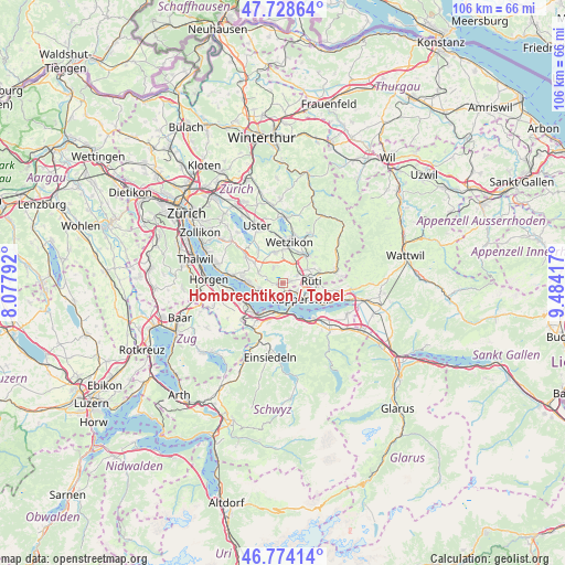
| Upper-left | 47.72864°, | 8.07792° |
| Center: | 47.25354°, | 8.78104° |
| Lower-right: | 46.77414°, | 9.48417° |
| Map W x H: | 106.1×106.1 km | = 65.9×65.9mi |
| max Lat: | 47.76737° ⇑48% North |
| Hombrechtikon / Tobel: | 47.25354° |
| min Lat: | ⇓52% South 45.83203° |
| min Long | Hombrechtikon / | max Long |
| 5.97153° | 8.78104° | 10.44624° |
| W 80.2%⇐ | ⇒19.8% E |
Elevation
Elevation of Hombrechtikon / Tobel is 491 m = 1611 ft, and this is 67.2 m = 220 ft below average elevation for this country.
| Max E: |
1845 m = 6053 ft | 46.1% |
| Avg. | 558.2 m = 1831 ft | |
| Hombrechtikon / Tobel | 491 m = 1611 ft | |
Min E: |
197 m = 646 ft | 53.9% |
See also: Switzerland elevation on elevation.city.
Geographical zone
Hombrechtikon / Tobel is located in North temperate zone (between Tropic of Cancer and the Arctic Circle). Distance of this North polar circle is 2147.1 km =1334.1 mi to North.| Distance of | km | miles | from Hombrechtikon / Tobel |
|---|---|---|---|
| North Pole | 4753 | 2953.4 | to North |
| Arctic Circle | 2147.1 | 1334.1 | to North |
| Tropic Cancer | 2648.2 | 1645.5 | to South |
| Equator | 5254.1 | 3264.7 | to South |


Nearby cities:
15 places around Hombrechtikon / Tobel: (largest is in red/bold)
• Binzikon
3.1 km =1.9 mi,  326°
326°
• Bubikon
3.2 km =2 mi,  61°
61°
• Bubikon / Station
3.6 km =2.2 mi, 57°
• Dorf
3.8 km =2.4 mi,  244°
244°
• Hombrechtikon
0.7 km =0.4 mi,  264°
264°
• Hombrechtikon / Bochslen
0.4 km =0.2 mi,  283°
283°
• Hombrechtikon / Eichberg
0.8 km =0.5 mi, 237°
• Hombrechtikon / Grossacher
0.4 km =0.2 mi,  230°
230°
• Kehlhof
3.8 km =2.4 mi, 236°
• Oetwil / Vogelsang
4.3 km =2.7 mi,  289°
289°
• Rapperswil
4.4 km =2.7 mi,  134°
134°
• Rüti / Westlicher Dorfteil
4.8 km =3 mi,  87°
87°
• Stäfa
4.5 km =2.8 mi,  254°
254°
• Uerikon
2.6 km =1.6 mi,  223°
223°
• Wolfhausen
1.4 km =0.9 mi,  77°
77°
Sources, notices
• [Note1] Compared only with cities in Switzerland existing in our database
• [Src1] Map data: © OpenStreetMap contributors (CC-BY-SA)
• [Src2] Other city data from geonames.org with taken over terms of usage.
• [Src3] Geographical zone / Annual Mean Temperature by Robert A. Rohde @ Wikipedia
