Dübendorf / Eglishölzli geodata
Dübendorf / Eglishölzli (Zurich) is a section of populated place; located in Switzerland in Europe/Zurich (GMT+1) time zone. With population of 913 people, there are 1399 cities with bigger population in this country. Compared to other cities in Switzerland, 75% of cities are located further ↓South; 68.7% of cities are located further ←West and 73.6% of cities have higher elevation than Dübendorf / Eglishölzli. Note1
Current local time in Dübendorf / Eglishölzli:
01:05 PM, SaturdayDifference from your time zone: hours


Dübendorf / Eglishölzli GPS coordinates[2]
47° 24' 23.436" North, 8° 37' 41.736" East
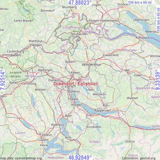
| Map corner | latitude | longitude |
|---|---|---|
| Upper-left | 47.88023°, | 7.92514° |
| Center: | 47.40651°, | 8.62826° |
| Lower-right: | 46.92849°, | 9.33139° |
| Map W x H: | 105.8×105.8 km | = 65.7×65.7mi |
| max Lat: | 47.76737° ⇑25% North |
| Dübendorf / Eglishölzli: | 47.40651° |
| min Lat: | ⇓75% South 45.83203° |
| min Long | Dübendorf / Eg | max Long |
| 5.97153° | 8.62826° | 10.44624° |
| W 68.7%⇐ | ⇒31.3% E |
Elevation
Elevation of Dübendorf / Eglishölzli is 434 m = 1424 ft, and this is 124.2 m = 407 ft below average elevation for this country.
| Max E: |
1845 m = 6053 ft | 73.6% |
| Avg. | 558.2 m = 1831 ft | |
| Dübendorf / Eglishölzli | 434 m = 1424 ft | |
Min E: |
197 m = 646 ft | 26.4% |
See also: Switzerland elevation on elevation.city.
Geographical zone
Dübendorf / Eglishölzli is located in North temperate zone (between Tropic of Cancer and the Arctic Circle). Distance of this North polar circle is 2130.1 km =1323.6 mi to North.| Distance of | km | miles | from Dübendorf / Eglishölzli |
|---|---|---|---|
| North Pole | 4736 | 2942.8 | to North |
| Arctic Circle | 2130.1 | 1323.6 | to North |
| Tropic Cancer | 2665.2 | 1656.1 | to South |
| Equator | 5271.1 | 3275.3 | to South |


Nearby cities:
15 places around Dübendorf / Eglishölzli: (largest is in red/bold)
• Brüttisellen
1.7 km =1.1 mi,  10°
10°
• Dietlikon / Dietlikon (Dorf)
1.5 km =0.9 mi,  331°
331°
• Dietlikon / Eichwiesen
1.5 km =0.9 mi,  338°
338°
• Dübendorf
1.3 km =0.8 mi,  214°
214°
• Dübendorf / Aesch
1.3 km =0.8 mi,  186°
186°
• Dübendorf / Birchlen
1.7 km =1.1 mi,  237°
237°
• Dübendorf / Frickenbuck
1.7 km =1.1 mi,  171°
171°
• Dübendorf / Grüzenstrasse
1.7 km =1.1 mi,  202°
202°
• Dübendorf / Im Zwinggarten
0.9 km =0.6 mi,  257°
257°
• Dübendorf / Kunklerstrasse
0.6 km =0.4 mi, 187°
• Dübendorf / Meiershofstrasse
1.4 km =0.9 mi,  228°
228°
• Dübendorf / Neuhausstrasse
1.4 km =0.9 mi, 205°
• Dübendorf / Sonnenberg
1.3 km =0.8 mi, 169°
• Dübendorf / Stägenbuck
0.6 km =0.4 mi,  221°
221°
• Wangen
1.4 km =0.9 mi,  65°
65°
Sources, notices
• [Note1] Compared only with cities in Switzerland existing in our database
• [Src1] Map data: © OpenStreetMap contributors (CC-BY-SA)
• [Src2] Other city data from geonames.org with taken over terms of usage.
• [Src3] Geographical zone / Annual Mean Temperature by Robert A. Rohde @ Wikipedia
